Using geospatial technologies to develop
participatory tools for natural resources management
![]() No. 53, May/June 2003
No. 53, May/June 2003
Using geospatial technologies to develop
participatory tools for natural resources management
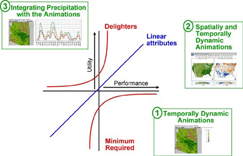
The Kano model, depicted with attributes provided by RangeView. Note that RangeView's first innovation -- temporal animations (1) -- is an attribute now considered expected, while spatially dynamic animations (2) meet fundamental needs and are viewed as normal performance. Adding new data such as precipitation (3) is currently unexpected, and thus perceived as a bonus. As the participatory process continues, the role and influence of each attribute evolves, as does its placement on the graph. |