Water efficiency II: Rural areas and agriculture
![]() ALN No. 57, May/June 2005
ALN No. 57, May/June 2005
Water efficiency II: Rural areas and agriculture
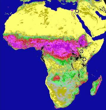
| In this image, each research area is marked with a circle, from south to north: Kajiado District and Turkana District in Kenya, and the Negev in Israel. The summer of 1984 was characterized by severe drought in Kenya; both the Kajiado and the Turkana Districts are marked by the color yellow signifying the lowest vegetation activity NDVI class (Bruins et al. 2003).
Source: prepared by Bruins with GIS software from the FAO-ARTEMIS NOAA AVHRR data base (FAO, 1993). |
 |