
|
|
|
MEMP Homepage |
Recommendations for Future Research
|
Erosion has been identified by a variety of researchers and policy makers as the most serious environmental problem in Malawi, as evidenced by references in the National Environmental Action Plan, the State of the Environment Report, and numerous World Bank and other donor-sponsored studies. The link between erosion and agricultural productivity is particularly significant: the declining spiral that results from initial soil loss, falling yields and subsequent reduced cover exposes more soil to erosion. Unfortunately, erosion is one of the most difficult environmental problems to measure in absolute terms and monitor at different scales. Most estimates to date have been based on the results of plot-based empirical modelling, most commonly the various derivations of the Soil Loss Estimation Model for Southern Africa (SLEMSA), developed initially by Elwell for Zimbabwe in 1978. There appear to be two general objectives: a) to improve the information available at the field level to help farmers identify erosion risk, and b) to improve regional and national reporting of the overall erosion problem to identify high risk areas in order to better target mitigation efforts.
These objectives demand accurate soil loss estimates, at minimum in relative terms. This necessitates improved understanding of Malawian conditions and efforts to incorporate those conditions into the SLEMSA method. This will require research that should be prioritised according to importance and uncertainty. We recommend three key themes in that research:
We are fortunate in that research of the type suggested in the first objective has been recommended by the original designers of SLEMSA and some efforts in this regard have already been undertaken in Malawi. However, we have identified a number of critical areas requiring further research that would have a large, positive impact on erosion hazard assessment capabilities in Malawi. The second objective has been recommended in a national soil erosion workshop held at Bunda College in November 1998, within the framework of the Malawi Environmental Monitoring Program. The final objective has been the subject of a number of larger erosion research projects in many parts of the world. We do not suggest a program at such a level, but rather an attempt to further investigate the application of SLEMSA (or similar models) to scales larger than the field scale for which they were developed.
Since SLEMSA is based on the Universal Soil Loss Equation (USLE) (Wischmeier and Smith 1978) and similar to the Revised Universal Soil Loss Equation (RUSLE) (Renard et al. 1997), it is possible to borrow heavily from what has been learned in developing these models. Furthermore, as we conduct research to improve SLEMSA, we will examine the requirements for the analogous factor in USLE, which tends to be more data intensive than SLEMSA. In this way, we will be able to more fully borrow from USLE, which has a more highly developed methodology for assisting in estimating parameter values, as data are collected over the long term.
Models for hillslope erosion estimation, including SLEMSA, are generally based on the factors influencing the likelihood of soil loss. These include the cover over the soil, the erosive effect of the rainfall, the erodibility of the soil, the topographic conditions, and the land use practices employed on the soil. Each of these are identified in SLEMSA, but are calculated primarily under conditions conducive to agriculture and livestock grazing, and in most cases based on the Zimbabwean example. In Malawi erosion is exacerbated by the need to farm not only the prime agricultural lands but also marginal areas often well above the SLEMSA/USLE 20% slope limitation. Other conditions (i.e. rainfall regimes, characteristics of cover, land use practices) vary enough from those currently captured in standard soil loss estimation models to warrant further research so that proper modifications can be made to suit Malawi. We have used the SLEMSA model to demonstrate the needs, though other similar models such as USLE and RUSLE would also require research to improve the accuracy of estimations.
There are a number of relevant data sets that can be used for SLEMSA research (Table 1). These can be obtained through the Malawi Environmental Monitoring Programme (MEMP), the Malawi Environmental Information System (EIS), the Ministry of Agriculture and Irrigation, and the Department of Meteorology.
Table 1. Data sets useful for soil erosion research in Malawi.
|
MEMP plot data (especially most recent year) |
Decadal rainfall data for 75 sites |
|
Bvumbwe data sets |
Slope class maps |
|
LREP soils and physiography maps and associated data |
DEM data |
|
LREP agroclimatic zone maps and associated data |
Agroecological zone map |
|
1:250,000 & 1:50,000 scale topographic maps |
Physiographic maps |
The details behind the SLEMSA method including associated equations are graphically depicted in Figure 1.
Figure 1. Soil Loss Equation for Southern Africa (SLEMSA), and data available for each parameter.
In SLEMSA, the energy intercepted has been related to the cover factor (C). This cover factor varies exponentially between 0 and 1. Elwell prepared a set of percent cover/yield curves for different crops in Zimbabwe. He then went on to relate crop emergence date to energy interception values for different yields and different crops in the Zimbabwe Highveld. Therefore the percent interception values presented cannot be used directly for conditions in Malawi where percent cover over time and rainfall energy over time may vary significantly. The current SLEMSA cover factor information must be modified to better suit Malawian conditions.
In order to improve the C factor for Malawi, it will be necessary to look at the various rainfall patterns in Malawi and compare these with the growth curves. Then i values can be estimated for different areas in Malawi for different crops. Also, because of the exponential relationship between C and i, most agricultural crops which have lower i values have much higher potential for error than forest or savannah which have i values greater than 50%. As such, while there may be more error in estimating the i values for forest and savannah, there is less error in erosion hazard estimate for forest and savannah (i.e. SLEMSA model is less sensitive to errors in i for i > 50%). This relationship is shown in Figure 2.
There are concerns about efforts to adjust the cover factor in SLEMSA. Because SLEMSA was originally based on USLE, which had wide application in Malawi in the past, it may be helpful to consider how adjustments were made in that equation for local conditions. In estimating the C factor in USLE, it is possible to estimate the effect of various contributions to the protective cover from the plant canopy, surface litter, surface roughness, and less commonly considered factors such as prior land use and soil moisture. These are commonly called subfactors. Typically in USLE, these subfactors can be estimated based on field measurement. SLEMSA, on the other hand, is more empirical, and has fewer guidelines for linking field measurements to estimates of C.
However, based on the cropping practices in Malawi, it appears that prior land use and soil moisture subfactors would be relatively unimportant in this case. Also with minimal surface debris the surface cover subfactor can also be ignored. The canopy cover subfactor can be determined by crop height and canopy cover. The surface roughness subfactor also needs to be calculated. It is doubtful that the cropping patterns used in Malawi are similar to any conditions described for RUSLE or USLE or even SLEMSA in its current form. Hence, it may be necessary to do field trials to obtain a C value (or estimates to obtain the analogous cover subfactors in USLE) that is more appropriate for Malawian conditions and have direct application in each model.
Non-agriculture cover types are also of concern in Malawi, particularly where forested areas are now under pressure for cultivation. However the impact of vegetation cover, and the resultant estimated erosion hazard value, for covers exceeding 50% (as is the case in wetlands, tree plantations, natural woodland and exotic woodland in Malawi) does not vary greatly when using SLEMSA (Figure 2).
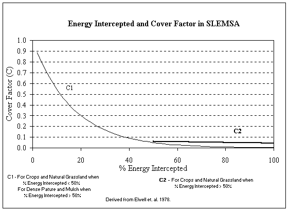 |
Figure 2. Relationship between energy intercepted and cover in SLEMSA.
Primary differences of cropping in Malawi versus cropping in Zimbabwe include: multiple crops in a field, different plant spacing and different percent cover versus time (due to phenology), and the application of fire. The bare cover after fire may be a particular erosion hazard if the fire comes prior to the rainy season. The cover types where particular emphasis is necessary for research in Malawi are noted below.
Traditional mixed agricultural cover is a particularly important cover type for Malawi because it provides the least cover protection among the most common vegetation types found in the country. Furthermore, there are no existing guidelines for estimating this cover type in the SLEMSA literature. A study could be designed to obtain an initial estimate of the C factor by examining existing data. However this would not be adequate on its own and a field trial would also need to be conducted.
A percent cover versus time graph exists for the mixed cover conditions at the Bvumbwe Agricultural Station prepared for the Bvumbwe catchment study. This can provide a first approximation to percent cover versus. time. It might also be necessary to use the rain gage data from Bvumbwe to understand the protection provided by the canopy through time. Furthermore, because of the potential variation in crops in a single plot, it may be necessary to have several plots of traditional mixed cover from the same location to understand the variability of the protection provided by various mixed covers. Percent cover versus. time curves can be constructed for any farmers’ field, though it would not be necessary to have a true field trial for this.
Tobacco is one of the few crops in Malawi (outside of tea, coffee, sugar and cotton, which all cover much smaller areas) that is regularly mono-cropped. For quality control, the buyers require specific cultivation and planting techniques, so that a single study would allow a cover factor for tobacco to be determined.
Since land may be left fallow for up to four years, a variety of different covers may constitute fallow conditions. Fallow lands in Malawi are not typically plowed and cleared each year, but left unattended which allows weeds and small trees to grow freely providing some cover protection. Fields may be left fallow for a portion of a year, or for several years. Longer fallow periods should provide better cover conditions. Fallow lands may be grazed or burned and thus may or may not have good cover protection. Also, such fallow fields often have ridges left from previous years. Therefore, it would be necessary to do numerous field trials to get a mean value for cover in fallow or abandoned land.
Note: It is important to realize that this definition is not the same as the "continuous fallow" condition in USLE, which is bare tilled condition with specific attributes.
Ungrazed natural woodlands and plantations generally provide good protective cover. Because the effect of cover is exponentially declining, the difference in the effect of cover becomes minimal above about 50% (Figure 2). As such, there may be little difference in the soil loss beneath a 50% cover and beneath an 80% cover. Field trials under such conditions may not be necessary, though mean estimates for canopy height and cover for the major vegetation types must be obtained. In addition, phenology (particularly the timing of the loss of leaves) may be an issue relative to rainfall. Finally, it is likely that both frequent fires towards the end of the dry season, deforestation, and selective tree and branch cutting may be having a significant impact on soil loss and thus should be considered in future model research. Further, research in these different types of cover will assist in improving land cover mapping in Malawi, which in return would be very useful in making the model more applicable at the regional level using geographic information systems (GIS). Figure 3 provides an example of a land cover map for all of Malawi derived from the 1991 Satellitbild/Forestry Department vegetation maps originally made at a 1:250,000 scale.
Since erosion is greatest when there is poor cover and strong rains, both temporal and spatial variability of rainfall must be considered. In developing SLEMSA, two different rainfall energy relationships were developed to account for spatial and temporal variability of rainfall in Zimbabwe. Currently rainfall data exist for 75 non-recording rain gage sites in Malawi at 10-day
Figure 3. Land cover map of Malawi.
Rainfall energy (E in SLEMSA) is currently calculated based on the rainfall depth using relationships developed in Zimbabwe for non-guti areas (E = 18.846 P). Paris (1990) used this rainfall energy relationship for rainfall depths between 800 to 1200mm. Unfortunately, rainfall in parts of Malawi (Figure 4) exceeds twice the annual rainfall for the station with the highest rainfall used to produce the original non-guti regression relationship (958mm at Gokwe in Zimbabwe). In the one case for rainfall greater than 2000 mm for Zimbabwe (for Guti Rain from Stapleford Forest) the rainfall energy regression relationship seems to be a reasonable predictor of rainfall energy for higher rainfall depths for Guti areas of Zimbabwe. However, it is not clear what the rainfall depth/energy relationships are for non-Guti areas receiving greater than 958mm of rain, such as occurs in Malawi.
Rainfall energy remains a major question mark in the applicability of SLEMSA in Malawi because the rainfall depths in Malawi can be significantly higher than in Zimbabwe. Furthermore, the rainfall energy regression relationships developed in Zimbabwe may not be appropriate for Malawi.
Research is required to determine rainfall pattern distributions through time and space. This analysis could be achieved through analysis of existing decadal and monthly rainfall depth data. It is necessary to have an understanding of temporal variability so that the relationship between crop growth and rainfall energy can be better understood since the phase of greatest erosion hazard is the period when the crop is small and rainfall energy is high. It will also be important to identify zones where rainfall patterns and types are similar so that these rainfall energy/crop growth curves relationships can be grouped into a workable number.
Another important area of research would be the verification of the relationship between rainfall depth and rainfall energy in Malawi. This could be conducted with existing Malawi Environmental Monitoring Programme (MEMP) plot data, along with supplemental digitised rain gage charts from Meteorology to evaluate the return period for Malawian storms. To determine the rainfall depth/ rainfall energy relationships it will be necessary to use recording rain gage data that have both rainfall intensities (from which rainfall energy can be calculated), and rainfall depths. At present, there are four years of data from the four MEMP plots in different parts of the country. It will probably be necessary to supplement this with longer periods of record from 25 Meteorology Department rain gage stations with recording rain gage charts, though these are not currently digitised. These data should be digitised in phases as it becomes clear which types of data and locations would improve estimates.
Finally, it will also be essential to update existing rain gage collection system. Many of the Meteorology Department’s recording rain gages are not currently working. It will be necessary to verify that these rain gages are collecting reasonable data. It will also be necessary to repair what is possible to repair and replace the rest.
Figure 4. Mean annual precipitation map for Malawi.
Topographic factors are comprised of slope steepness (S) and slope length (L).
SLEMSA uses the topographic factor developed for the USLE, adjusted to reflect a standard plot with 4.5% slope 30m long plot, instead of the 22m long 9% slope plots used for the USLE. The developers of SLEMSA limited the use to slopes less than 20%. This is problematic as slopes greater than 20% are common in Malawi, and heavy land pressure is pushing cultivation into these more marginal areas.
There is also an issue of the relationship with the slope length selected, the actual percent slope, and the resulting topographic factor, particularly for steep slopes (Figure 5). This is of particular concern when efforts are made to use a model such as SLEMSA to map relative soil erosion hazard at scales larger than the field. In addition Figure 5 shows that SLEMSA is not sensitive to slopes less than 20%. These shallow slopes represent extremely important agricultural lands, making this a serious limitation. The curves representing changing slope length appear to fall into several groups with similar slopes. The SLEMSA topographic factor becomes more sensitive to slope length on slopes steeper than 40%.
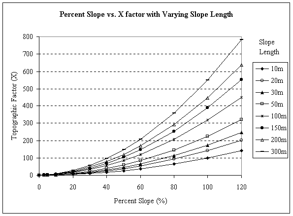 |
Slope length can easily be estimated in the field. However, it is not clear how the slope length factor should be applied in larger-scale spatial applications. However, this topographic submodel is limited to conditions with less than 120 m slope lengths and 20% slopes. As such it is not applicable to many parts of Malawi. On the other hand, the RUSLE topographic model allows for slopes as long as 300 m. Furthermore, the RUSLE slope relationship has been tested at up to 84% slopes.
Figure 6 provides a graphic representation of this problem for the Middle Shire region. Note that 8% of the land area in this region is not captured by the original SLEMSA slope equation, even when 90 meter grid cells are used for the analysis. This 8% corresponds in a large part to the marginal land in Malawi currently under great pressure for cultivation as the population grows. While this land is generally poorly suited for agriculture, it is nonetheless being converted to cultivation, and is a major contributor to the accelerated erosion evident in Malawi. It is essential that future soil erosion hazard research in Malawi address this problem.
A starting point for addressing these issues would be to adapt the RUSLE topographic Model to the SLEMSA. Since the topographic model in SLEMSA is essentially the USLE model, it is conceptually valid to substitute the RUSLE topographic submodel into SLEMSA. However, there are differences in the USLE and SLEMSA versions of slope length that will have to be resolved prior to any attempt at bringing in what was learned on RUSLE for these steeper slopes.
It may also be important to conduct a sensitivity analysis to better understand the relationship between slope length and slope steepness. Particular emphasis should be placed on the impact of extending SLEMSA results to larger scales for regional mapping (where the slope length selected is often much greater than what would be used at the field level).
In a study of soil erosion and sedimentation assessment in the Karonga ADD, undertaken by Mwafongo et al. (1998), a regional approach to assigning slope steepness and slope length was used to calculate the X factor of SLEMSA. Three average slope classes were derived from the 1:50,000 topographic maps for each of three major agro-ecological zones as outlined by Eschweiler (1991). An associated slope length, defined as distance from crest to drainage line, was also estimated from the 1:50,000 topographic maps for the study area in central Karonga scarp zone and lakeshore plain. These were as follows:
| Percent Slope | Slope Length |
Agro-Eocologic Zone |
| 4.5% | 120m |
Kyungu Lowlands |
| 10% | 60m |
Karonga Lakeshore Plain (centre) |
| 20% | 25m |
Karonga Escarpment (east and centre) |
We recommend that this approach be extended to all the physiographic units in Malawi. These efforts could be improved with field reconnaissance work where a sampling strategy is worked out to measure typical slope lengths in the field and compared with those estimated from high resolution topographic maps and revised where necessary.
Figure 6. Impact of slope limitations of SLEMSA.
A similar approach is to investigate the possibility of assigning average slope lengths to recently available LREP soils/physiography maps which includes information regarding landform categories for the southern part of the country and can be easily manipulated for regional erosion hazard assessments. Deriving a slope length for each land cover class in a physiographic unit also has potential to improve the estimates of effective slope length.
Soil erodibility (F) and land use practices (called P in USLE) are separate factors in SLEMSA, but are addressed together in this report as they are related, particularly when considering research design. The F value in SLEMSA is the sum of a base soil erodibility value (Fb) and correction factors based largely on Practice (P) factors, which account for cultivation practices, previous cropping conditions and other factors. The base soil erodibility value (Fb) can be estimated based solely on soil texture with 4 being a starting value for sand, and 6 being an initial value for clay (HM5, SLEMSA Manual). Data in the Land Resources Evaluation Project (LREP) soils and physiography map would easily lend itself to estimating a base soil erodibility value.
The soil erodibility factor has a base soil erodibility factor (Fb) which is a function of inherent soil erodibility, and correction factors for practice (called P in USLE, and used as additive correction factors to transform Fb into Fm in SLEMSA). The existing ridging factor to modify the overall F value is based on ridges as constructed by farmers in Zimbabwe. Since the cultivation practices in Malawi (hand hoed, ridges typically 0.6 m high at about 1m spacing) are different from those in Zimbabwe (shallower, ox-plow ridges, and closer spacing), there is a need to develop correction factors in SLEMSA to account for Malawian conditions. It is therefore necessary to determine the P factor for the cultivation practice for USLE as well as for SLEMSA.
The base soil erodibility (Fb) can currently be estimated using the soil family, soil group and soil texture. Also, a simplified method is to use simply soil texture. However, Elwell has said that the soil erodibility factors are not easily determined, and expert opinion plays a major role in selection. Therefore it may be wise to try to improve the estimate of Fb by relating it not just to texture, but to other factors. The following is recommended:
Measure easily determined characteristics of a soil (e.g. %Organic Matter, pH, soil structure, texture and other factors described in the LREP soils maps), and run rainfall simulator exercises to calculate Fb. Then use the parameter estimation process to improve estimates of Fb by relating Fb to texture and other easily-determined characteristics.
Research would involve a rainfall simulator study. Once a base value for Fb has bee determined, the soil can be ridged as it is in Malawi. Scenarios could include the recommendations of the Ministry of Agriculture and Irrigation (ridge construction of 0.9m between ridges, 0.9 m between maize plants, and 0.6m in height) and Traditional ridge construction ( >1m between ridges, shallower ridge heights and wider maize spacing).
The role of erosion inhibiting vegetation should also be considered. For example, vertiver grass has been promoted in Malawi and this could be evaluated in a plot study at different ridge spacing. A trial would need to have a constant, known Fb and land in bare fallow without ridges to isolate the effect of vertiver alone.
The effect of box ridges should be studied using plots and a rainfall simulator. The effect of boxed ridges can be determined once Fb is known, in trials similar to those recommend for erosion control plants.
The relative impact each factor may have in a particular soil loss model is critical, particularly if attempts are to be made to modify a model to suit Malawian conditions. Therefore it is recommended that sensitivity analysis be conducted before and after any new developments are made with any factor. Sensitivity analysis of a model such as SLEMSA or RUSLE is defined here as a method to determine the relative and absolute significance of model input parameters in affecting the model output. Implementing/performing/conducting a sensitivity analysis of the model input parameters aids in determining data collection and experimental needs and provides further insights into the physical processes.
Khonje et. al (1987) performed a crude sensitivity analysis for computing erosion hazard units (EHU) that was based on SLEMSA. In their analyses they investigated the effects of increasing and decreasing the subfactors by an arbitrary percentage and, in the case of the erodibility factor (F) by +/- 1. This method showed that the EHU computation is first sensitive to the crop factor and secondly to the erodibility factor (F factor) and the sensitivity to slope steepness and erosivity is weak. Mughogho (1998) performed an sensitivity analysis by increasing the three control variable (F,i,S) each by 15%. She found that the most sensitive parameter is the K factor since the 15% increase in the F factor caused a ~ 22% decrease in the resultant Z. The same analysis for the topographic ratio revealed a 15% increase in S resulted in a 15% increase in soil loss (Z). The last variable increased by 15%, the I value, resulted in only a small percent decrease in soil loss, ~4%. Mughogho used the following equation
Percent change =
 |
where Iv is the varied variable or the variable with a 15% increase and Ib is the base value for that variable.
Where as the above methods provide insight into of the sensitivity of each parameter, the sensitivity index permits incorporation of a whole range of variations. It also permits calculation of the sensitivity over a large range rather than for simply one or two variations such as increasing each variable by 15% or increasing as well as decreasing the input values for a variable by an arbitrary +/-10%.
The sensitivity index is determined for each input parameter: energy interception, rainfall energy, soil erodibility, and the topographic factors of slope steepness and slope length. While one parameter is analysed, values for all other parameters are held constant. The sensitivity index represents a relative normalised change in output to a normalised change in input, allowing a valid means of comparing sensitivities for different input parameters that have different orders of magnitude.
The sensitivity index, SI, is given by
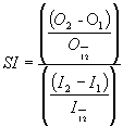 |
where I1 and I2 are the least and greatest values of input used, respectively, I12 is the average of I1 and I2, O1 and O2 are the associated outputs for the two input values, and O12 is the average of the two outputs.
We recommend that all research designed to improve the current soil loss estimation efforts in Malawi include sensitivity analysis both prior to actual field trials and after the appropriate changes have been made in factors and/or the underlying method.
Hillslope erosion models such as SLEMSA or USLE have often been used to do erosion hazard mapping at regional and national scales, despite the fact that they were developed as conservation planning tools for farmers. They are useful for understanding the effect of different cropping and conservation scenarios on hillslopes. As such, they provide a simple means to address questions such as: how to estimate soil loss on a hillslope when a forest cover is removed and replaced by agriculture. Because other types of models are less capable of answering this particular type of question, models such as SLEMSA and USLE have become popular as erosion hazard assessment tools.
In choosing to use SLEMSA as an erosion hazard assessment tool, it is important to understand that there are many shortfalls with the method. Some of these problems can be addressed in application, some cannot. This discussion describes practical and theoretical problems with the SLEMSA (and USLE) models, and then proposes methods for addressing these shortcomings within the SLEMSA model, and by cross-checking the results of the method against other erosion hazard assessment tools.
In using SLEMSA as a regional, erosion hazard assessment tool the following practical considerations must be taken into account:
Unfortunately, while changes in cover types are often instrumental in changing sediment yield in a watershed, SLEMSA is unable to capture the dynamics of the processes at scales greater than the hillslope. For example, in Malawi, gullies on hillslopes are a clear sign of accelerated erosion. Unfortunately, SLEMSA does not account for the effects of gullying. Furthermore, watershed degradation problems that include sedimentation and changes in stream baseflow, cannot be accounted for in the SLEMSA model.
Problems of scale can be obfuscate the magnitude of soil loss thus are critical in understanding erosion and sedimentation. For example, only 10 percent or less of the calculated to be soil lost from a hillslope may actually be transported out of a drainage basin. The remainder is simply moved and deposited somewhere between the hillslope and the large drainage basin. Thus, most soil loss estimation techniques, including the SLEMSA model, fall short in their ability to capture scale issues associated with erosion hazard assessment.
Studies of sediment dynamics have often shown that most erosion in a season can be attributed to a very few number of storms when thresholds are exceeded. As such, the mean annual rainfall in a season may not be a particularly good predictor of soil loss. However, if rains come when crop cover is poor, more erosion will occur than if rain comes when crop cover is good. Therefore, SLEMSA cannot capture hazard associated with thresholds that may vary regionally.
Many factors that can be estimated at the scale of a farmer’s field are difficult to assess on a regional basis. For example, tobacco, which is mono-cropped, may be identified at the field scale, and SLEMSA provides methods to estimate the effect of tobacco cover on erosion. However, it is doubtful that individual tobacco fields can be identified at the regional scale. Furthermore, the effect of cover protection provided by mixed cropping common in Malawi cannot be estimated with the existing guidelines.
In addition, topographic factors, especially slope length, vary widely in a single watershed. As such, it is not clear what slope length is appropriate for application of SLEMSA to the regional scale.
While the practical problems described above may also be considered to be theoretical problems by some, the primary theoretical problem is that SLEMSA is a regression-type model developed for a different set of conditions than those in Malawi. Such a regression equation is only valid under the conditions for which it was developed. The farming practices, covers, and rainfall in Malawi are all different than those in Zimbabwe where the SLEMSA model was developed. As such, it is not clear that these regression relationships are valid for conditions in Malawi.
Despite the limitations of SLEMSA, the ability of the model to address the important problem of estimating the effect of change in cover or land use on erosion makes it a powerful tool for understanding the questions most often of interest by policy makers. Therefore, in applying SLEMSA to regional soil erosion problems, the following should be considered:
Cover: Cover Types Should be Limited to Those that Can be Identified With Regional Characterisation Tools Such as Satellite Imagery: The cover change analysis carried out by MEMP in the Nsipe EPA identified a limited number of cover types that could be identified using satellite imagery and ground verification. In this analysis it was impossible to identify differences in agricultural cover. Since intercropping is common in Malawi, characterising cover with a single crop type does not adequately describe the cover conditions.
Topographic Factors: In a watershed, there may be many different hillslope lengths. These may vary by cover type as well. While there are clearly many different hillslope lengths in reality, it may be possible to use a single effective length that has regional validity.
Because of the many difficulties in using SLEMSA as an erosion hazard mapping tool, it would be helpful to look at other types of assessments that may provide a cross-check.
Catchment Scale Field Studies: Watershed scale erosion research has been carried out at the Bvumbwe Agricultural Research Station. Applying SLEMSA for those same years on for which data exist would provide a watershed scale estimate of the effectiveness of using SLEMSA as an erosion hazard assessment mapping tool. Sedimentation rates in small ponds or dams where the age of construction is known may provide independent measures of soil loss. These could be cross-checked by looking at the SLEMSA estimated soil loss in those same catchments.
Erosion Hazard Scoring: In addition to developing SLEMSA, Elwell (1976) developed an erosion hazard scoring system for Zimbabwe. This scoring system takes into account population pressure as well as topographic factors, climatic factors and cropping practices. Therefore, some of the factors in scoring are also considered in the SLEMSA model, but as a calculation. Scoring has the advantage of being able to consider some common sense problems not specifically noted in SLEMSA (e.g. higher population density will probably produce higher erosion hazard). Scoring has the disadvantage that it is not clear if areas with the same score actually have the same erosion hazard. However, it might be possible to use this iteratively with other techniques to develop a good estimator of erosion hazard.
Geomorphic Indicators: Drainage density (the length of stream channel per unit area) and drainage texture (the number of first order channels per unit area) have been correlated with soil loss. As such, they are independent measures of erosion not considered at all in SLEMSA, which does not consider the effect of channels. The problem with geomorphic indicators is that many channels are too small to show up on topographic maps. Therefore, it is not clear that the true effects recognised in the field can be accounted for on maps. Changes in land cover that may markedly impact erosion will likely not affect the drainage pattern until many years later. Furthermore topographic maps capture the drainage network at a particular moment in time. Therefore, the effect of land cover change on erosion cannot be determined with such analysis of topographic maps.
Because the methods mentioned above, (including SLEMSA and USLE) have their own limitations, there is no consensus as to the proper method of erosion hazard assessment at the regional scale. While there are benefits to cross-checking the results of a SLEMSA with other methods, erosion hazard assessment remains a difficult task with no clearly superior method.