|
|
|
MEMP Homepage |
Introductory and intermediate GIS Training:
|
This report summarizes observations made during the second Introductory Training Course in Geographic Information Systems (August 3-12) and the first Intermediate Course (August 15-18) held in Lilongwe, Malawi, at the Department of Research and Environmental Affairs (DREA).
These courses fit into a three course sequence (Introductory, Intermediate and Advanced) that provide a comprehensive background in GIS for government analysts involved in environmental monitoring. The introductory course is intended to provide a broad overview to GIS and Image Processing and their use in environmental research. The intermediate course provides hands-on experience with database development issues and a strong exposure to change analysis procedures for environmental monitoring. The advanced course covers database design and system implementation, error analysis, and procedures for multi-criteria / multi-objective decision making. In addition to these courses, trainees are involved in more informal workshops and advising sessions as well as a pilot project study.
The courses were conducted by Ron Eastman, Rheyna Laney and James Toledano from Clark University, USA. Appendix I details the eight day course schedule for the introductory course and Appendix II the four day intermediate course. Materials covered during the introductory course included fundamental concepts and analytical procedures in GIS, an introduction to Remote Sensing and Digital Image Processing, and an introduction to the use of Global Positioning Systems (GPS) for field studies. Materials covered during the intermediate course included raster and vector data import, interpolation and change analysis for environmental monitoring. This report identifies key observations from having interacted with our Malawi colleagues during the these training courses.
The trainings were attended by 23 trainees from the Department of Forestry, Land Resources Conservation Branch, the Department of Meteorology, the Department of Surveys, the Department of Water, the Department of Research and Environmental Affairs, and the Department of Fisheries (see Appendix III). The majority of those attending the intermediate course attended the previous introductory course in April 1994.
Of particular note was the presence of all of the original introductory trainees at the intermediate course except for those that we recommended not attend. With the addition of a strong new group from the introductory session, it is reasonable to suggest that a strong core of GIS analysts is now being developed. This core will be crucial for current and future activities of MEMP, as well as the long-term institutionalization of GIS.
2. Following our recommendations from the first training last April, a much stronger and careful recruitment process has been adopted. This has led to a more qualified and analytically-oriented group for this introductory training as compared with the last. The overall skills of these trainees were much less variable, making for a much more effective and productive training course. Indeed, two of the introductory participants showed such a strong aptitude that we invited them to participate in the intermediate course that immediately followed.
3. Since the last training session, two GIS User's Groups meetings have been held. This is an informal group initially comprised of the trainees from the introductory course last April. We hope this will continue as it fosters cooperation among this small but growing group of GIS analysts in Malawi. Also, it acts as a good forum for maintaining enthusiasm. Currently the group is looking into formally incorporating itself as a sub-group within the National Committee on Remote Sensing.
4. With the arrival of the hardware and software, and our continuing interaction with the group, enthusiasm is currently very high. However, there is an overall concern by the trainees that there is a lack of support within their respective agencies for GIS activities. As indicated by the participants, this is largely a result of insufficient information about the nature and potential of GIS being communicated to those in a supervisory role. This is contrary to the initial observation that was communicated to us in April, and one which we feel is significant to the successful institutionalization of these new and important technologies.
To adequately plan for the institutionalization of GIS and for the trainees to continue their development, follow-up activities are planned through January 1995. For the trainees just completing the introductory course, they will benefit from their colleagues in their respective agencies who have just completed the intermediate course. The introductory trainees will continue to sharpen their skills through follow-up exercises through to the next intermediate course scheduled for January. At that time, an advanced course is also planned.
The most important follow-up activity will be in the development of pilot projects for each of the agencies. This was initially discussed during the intermediate training and will be organized during the immediate weeks following the training by James Toledano, who will conduct site visits to work with each agency through September. These pilot projects will serve multiple purposes.
Foremost, these pilot projects will ensure the continued development of their GIS skills. Some pilot projects that are planned are: 1) to analyze the relationships between agricultural yields and physical properties such as soils; 2) to develop relationships between groundwater quality and soils, water level and fertilizer input; and 3) to develop spatial relationships between aphid infestation due to drought in forested areas. The trainees are clearly at a level to begin on the development of the databases for these projects.
Also, these pilot projects will assist in awareness building within the MEMP participating agencies. Currently, most of the trainees are caught in a catch-22. Although the trainees themselves understand the potential for GIS technology within their agencies, this potential is not being adequately conveyed and thus there is a lack of broad agency support overall. The pilot projects provide an excellent forum for alleviating this problem. In addition, preliminary needs assessments during the site visit stage will also contribute to awareness building. At the end of the preliminary planning and initial database development of the pilot projects, a one-day evaluation meeting is planned with the trainees to share experiences and ideas for further development of the pilot projects and other agency and MEMP related GIS activities.
In order to assist in the development of agency understanding and support for the activities of MEMP and GIS, James Toledano will also give an overview of activities to supervisory personnel during each of his agency visits. In addition, we are looking into the possibility of conducting a sensitization workshop to provide an overview to upper-level management in key agencies.
Malawi Environmental Monitoring Program
DREA, Lilongwe, Malawi: August 3-12
Malawi Environmental Training Program
DREA, Lilongwe, Malawi: August 15-18, 1994
[ text] introductory course
Human Capacities
Of major note is the building of human capacities within each of the participating agencies. There is a collective learning process that is just beginning to take shape within and across the agencies. It is most noticeable in the increasing level of technical conversations regarding information technology with each of the agencies and trainees in the development of the pilot projects. GIS was little known but four months ago, however, at present there is not only an increasing acceptance of the tool, but also, appropriate dialogue is progressing about its current and future capabilities. Although the onus is currently on the trainees the pilot projects will continue to sensitize and stimulate dialogue in the months ahead.
This learning process is difficult of characterize but it also manifests itself in the increasing dedication observed with those Government of Malawi officers participating in the GIS training program. Although the technology was never suggested to be transparent in use or highly accessible, the many hurdles faced during the past month have been met during the database development process. For the most part, this is because trainees have become increasingly aware the role information technologies can play for the monitoring of natural resources and the environment in Malawi.
Data
The pilot project stage provided the best opportunity to demonstrate the importance of data for developing the capacity to use new technologies for environmental monitoring. Each agency exhibited different and demanding needs for data, especially regarding data quality, storage and management. For the most part, there is a wealth of data available in Malawi in a myriad of formats including maps with and without reference systems, as well as tabular data in both digital and hardcopy formats. There is even an increasing amount of map data being supplied by the participating agencies specifically for the MEMP.
One of the significant realizations by the agencies was the amount of data entry and massaging needed before analysis and mapping is possible, regardless whether existing or newly digitized data is utilized, although this is routine in the development of a database. A major factor in this time consuming process was the fact that little of the data available was ever conceived to be used with newer technologies such as GIS. The benefits of collecting and storing data in alternative formats than they have been traditionally is now becoming evident, especially if data is going to more accessible and efficiently utilized in the future. Much must be done, however, in the form of National and Departmental coordination and planning to realize a coordinated data collection and storage effort, much along the line of a National Mapping Program.
Land Resources and Conservation Branch (LRCB)
LRCB has one trainee through to the intermediate GIS course and one trainee through to the introductory course. The most recent trainee is stationed at the Mzuzu ADD. This is the first attempt at decentralizing the technology to the regional centers.
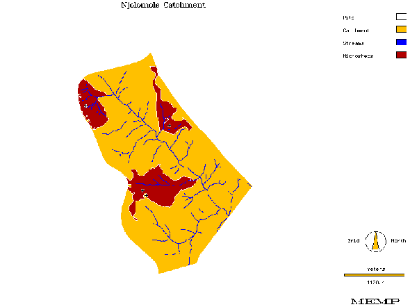
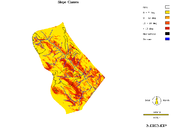
The LRCB pilot project, with assistance from a trainee from DREA, is conducting suitability mapping of the MEMP watersheds for siting of field-level erosion monitoring structures. The Njolomole watershed was the first watershed completed with the analysis used to assist Nick Mokhothu (The University of Arizona) in stratifying the watershed for siting of four monitoring structures (Figure 1). The analysis for Njolomole consisted of digitizing a 1:5000 map specifically commissioned for the project and developed by the Department of Surveys. A digital elevation model was then created for use in deriving a slope hazards map (Figure 2) and for the identification of the micro-drainages in the Njolomole watershed. The next phase is to digitize all remaining watersheds and to incorporate soils and landuse data for further stratification.
Department of Forestry (DOF)
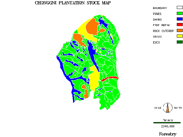
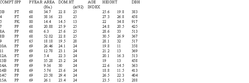
DOF has two trainees through to the intermediate GIS course and two trainees through to the introductory course. The DOF project is to map the Chongoni Forest Plantation using a recently surveyed map (1992) and a recent database (1993) for the plantation which includes information on species, age, area, slopes, etc. (Figures 3 and 4). DOF has many plantations throughout Malawi so this project is being looked at closely for monitoring their forest resources. The plantation maps, produced through chain and compass, present a unique problem for GIS as they contain no reference grid. They are, however, produced to scale and a pseudo grid to scale was superimposed for digitizing purposes. Later, through ground truthing and GPS surveying, the map will be resampled to the Malawi UTM grid.
Department of Meteorology
DOM has one trainee through to the introductory course and two trainees through to the intermediate courses. DOM's current project is to look at ways of streamlining and automating the dekadal and monthly meteorological data they report on. Their current reporting structure consists of: 1) the collection of rainfall data every ten days from selected reporting stations; 2) the production of surface rainfall maps from these statistics; 3) the production of a report every ten days that includes an executive summary of the rainfall statistics and maps showing actual rainfall during the 10 day period and a cumulative map for the season; and 4) a monthly report that includes all the above data plus the tabular statistics themselves.
Currently, the automated collection capabilities at DOM are limited as is the storage of the data. Only hardcopy archives exist from all previous months of digital analysis of the data. Archiving procedures as well as streamlining and further automation of their current reporting system are being explored using the office sweet of tools provided by the project.
DOM had also expressed much interest in using GIS for analyzing NDVI and cold cloud duration data that is digitally received every ten days from Harare, but it was felt that much more preparation was needed for this activity. Although several scientists at DOM had ideas for using the data, the one member of department extensively trained for this purpose has recently taken an early retirement leaving the department without any expertise in this field. It was concluded that the use of this data for a pilot project would be better pursued in January once the two newer trainees complete their exercises and conduct additional research.
Department of Surveys (DOS)
DOS has two trainees through the intermediate course and two trainees through to the introductory course. Because DOS is primarily involved with the development and archiving of mapped data, their pilot project will entail the collection of on-going pilot project output from the other departments in order to: 1) archive this digital data; 2) evaluate future archiving potential beyond MEMP; and 3) to produce high quality output products.
DOS just recently purchased photogrammetric software (SOS-Map, Sweden) that will encode data directly from the stereoplotter. They are still in an evaluation stage phase as the installation phase provided by the Swedes was not being followed-up by any practical training. The goal of course is to have direct input of plotted data into the GIS. This will be the focus of the second DOS GIS trainee group upon completion of their intermediate course.
Department of Fisheries
Fisheries (Monkey Bay) has two trainees through the intermediate course and two trainees through to the introductory course. The Fisheries pilot project will look at mapping fish area units within the southern portion of Lake Malawi. Fisheries has recorded catches since 1968 in tons per month per species per area. The primary focus of this project will be to map out total historical catches by area.
A second project identified was to do analysis on relationships with data recently acquired through a two year SADAC project that collected monthly data from transects across the lake on nutrient levels. Other data available includes bathymetry, meteorological data from five stations around the lake on wind speed, direction, rainfall and air temperature, also water department data on daily lake levels. All data for this project will be available in January.
To date, Fisheries at Monkey Bay has not received any equipment and are using existing computers which will not suffice in the future. The other two trainees are from Zomba and Mzuzu also do not have any equipment and resources to continue the training. Fisheries was taken on as part of the MEMP upon verbal agreement from The World Bank to commit resources for their training and follow-up. To date they have not responded and it is recommended that no further Fisheries officers be trained as they do not have proper resources to carry-on.
Department of Water (DOW)
DOW, Water Quality, has one trainee through to the intermediate GIS course and two from Hydrology through to the introductory course. The pilot project developed focused on water quality analysis, hydrology will begin their pilots after the intermediate course but they have already expressed interest in flood modeling in the Shire Valley. The water quality project is looking at analyzing data from 63 boreholes throughout the Central Region. Initially the project will map out different water qualities according to chemical analysis in the database. Future analysis will be to look for relationships with ground water, soils, etc. Altogether there are over 600 boreholes being monitored throughout Malawi.
|
|
|
|
|
|
Figure 4: Partial Summary of Results from 1993 Inventory of Chongoni Forest Plantation
|
|