
|
|
|
MEMP Homepage |
Progress report technology transfer under MEMPFebruary 28, 1995
|
This is a progress report on the continuation of the GIS technology transfer program under the Malawi Environmental Monitoring Program. The purpose of this trip was to conduct the third round of GIS trainings and to continue development of the GIS pilot projects. The second GIS intermediate course was given January 9 - 12 and the first advanced course was given January 18 - 21 by J. Ronald. Eastman and James Toledano. The course outlines and participant lists are found in Appendices I and II. Previous trip reports outline the scope of this phased training approach.
The training courses have been tailored around the degree of participation and level of adoption of the trainees. The problems identified in previous reports still remain, particularly those stemming from the lack of participation by the agencies in developing and supporting GIS activities. Progress is being made, however, in creating awareness within each of the agencies to increase this participation, albeit, slowly. Also, individual GIS skills continue to develop. The past two years have afforded us the unique opportunity to understand the historical political and institutional barriers to this process which are increasingly becoming more constraining than the technological ones. We have begun to elaborate on these issues in a Draft Report, February 1995.
In general, however, many are still not aware of the demands of GIS: the technology, the science, and the social change required for its adoption. Often GIS is mentioned as merely a tool as it is immediately seen for its physical properties and products resulting from the discipline of geography where it is invaluable for mapping, cartography, spatial statistical analysis, modeling, etc. What many are not aware of is the cultural divide between the development and implementation of technology in the North and the subsequent adoption process in the South which brings to the forefront those socio-technical issues of the technology transfer process. Clearly, these are the issues that should be given priority for any future activities under ASAP II.
The last round of training and pilot project development under ASAP I will be in May - June 1995. The last of the advanced courses will be given the second week in May followed by an intensive one week workshop. The workshop will develop around a resource allocation problem and mitigation model for the Mangochi Catchment. Already, an extensive database exists for the catchment and currently, Susan Moodie, The University of Arizona, is in the field conducting resource inventories and socio-economic data collection on the catchment to be used in this modeling exercise. This model will be significant in raising awareness and will be used for a Decision Maker's Seminar also scheduled in May in Mangochi. A draft proposal for the two-day seminar is found in Appendix III.
Department of Water
Discussions continued on developing a water quality monitoring GIS project using boreholes as the data source. However, any significant amount of work on the DOW pilot project was unsuccessful again this trip due to a lack of time for both the trainees and trainer. There is only one trainee working on this project and he has many other demands with in the department, especially MEMP related activities. The one other promising trainee has been transferred and is now without a GIS computer.
Department of Fisheries
Discussions continued on developing a fisheries project to monitor fish habitats in Lake Malawi. However, the Department at Monkey Bay is still without equipment. GIS computers are due to arrive before the final May training at which time the pilot project will be given priority.
Department of Surveys
The DOS is undergoing two activities in order to further develop their skills and capacity within the department to use GIS. First, DOS is exploring the use of multi-temporal imagery to detect change in landcover/landuse. A series of images from aerial photos and MSS and TM satellite imagery were either scanned or downloaded from digital archive for a region in Blantyre. Once resampled these series of images over the past twenty years will be used to evaluate change analysis techniques using GIS. Second, DOS is continuing to archive the digital mapped data from the other agencies as they are produced The DOS has also completed a preliminary needs assessment for their agency.
Department of Meteorology
Discussions continued on using the NDVI and CCD data received dekadally from Harare for rainfall monitoring and reporting. The major problem that is still left unresolved is the conversion this data into a usable format. Also, given the time of year, DOM trainees are busy gathering and reporting on National rainfall statistics. Upon completion of the May training, the DOM project will also be given high priority.
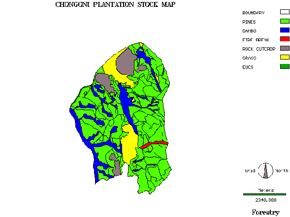
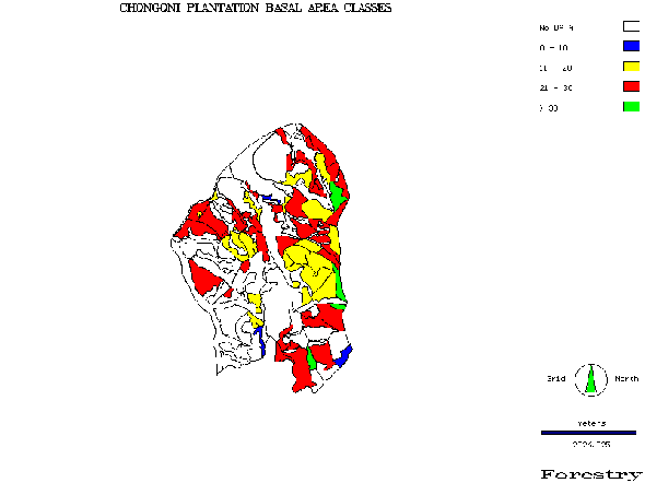
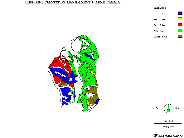
Department of Forestry
The DOF continued to work on their pilot project to map out the Chongoni Forest Plantation. Initial products are found in Appendix IV and it is planned that a full report of this project be given to the Chief Forestry Officer. DOF has also incorporated this project into an elaborate digital presentation using Microsoft PowerPoint Although DOF initially had four trainees participating, only one trainee has remained to carry-out the project. There is only one trainee who has completed through to the advanced course, but he has since been sent to Forestry College for two years.
Land Resources and Conservation Branch - MoREA
LRCB has made the most progress on their pilot project. One trainee has continued to develop the data sets for each of the MEMP catchments, especially the Mangochi catchment. The data was used to begin preliminary analysis on erosion potential within the catchment (Appendix IV).Digitizing will continue until the five catchments are complete. Also, catchment level/field level socio-economic and resource data are now being collected for the Mangochi catchment, other catchments soon to follow, that will be used in subsequent analysis and modeling of resource trends and mitigation scenarios.
A new pilot project was begun at the Mzuzu ADD. The one trainee from Lilongwe and the one trainee from Mzuzu are developing an initial database for the Nkhata Bay catchment that includes TM imagery and aerial photos. The study will look at producing landcover change and land resources evaluation for the catchment area initially, but to be expanded to the RDP level. Current landcover change and evaluation is only carried out at the ADD level and GIS will assist in the localization process.
January 9 - 12, 1995
January 18-21, 1994
Intermediate course
advanced course
May 30 - 31, 1995
The objective of the two-day seminar is to bring together environmental decision makers within the Government of Malawi in order to become familiar with the concept of GIS technology for environmental decision making in Malawi. Over the past year, under the Malawi Environmental Management Program (MEMP), government officers have been trained and experimenting with the use of GIS in the areas of forest monitoring, water quality, watershed planning, rainfall monitoring, and landuse planning. The seminar will be a venue for assessing the progress thus far and to elicit the needs of Malawi's environmental decision makers for implementing GIS in Malawi for environmental monitoring.
Tuesday May 30
 |
  |