
|
|
|
MEMP Homepage |
Clark University Activities
|
"You farmers go to Lilongwe to collect your thousands of Kwacha for tobacco and are proud of that yet you no longer produce chimanga (maize) anymore. You are reducing us to a village of beggars". Mandalasi Buluzi Phiri, Headman, Semu Chimwala Village Meeting, November 5, 1998.
Introduction
This trip was undertaken as part of Clark University’s involvement in the Malawi Environment Monitoring Program (MEMP), a program located within Department of Research and Environmental Affairs where the component being reported on seeks to assess the "social and environmental impacts of increased small holder agricultural production under market liberalization. The major objective of this trip was to gather basic and background Information on agriculture and changes among small holder farmers between 1994 and 1998. The overall objective was divided into seven specific tasks as follows:
In pursuing these tasks the team was ably assisted by Orpha Kabambe of Bunda Agricultural College and Patrick Jambo of the Department of Forestry. The sections that follow give a summary of the work carried out under each specific task while more details are contained in annexes where indicated.
Task 1: Key policy and technical documents.
A number of key policy and technical documents were collected and reviewed (see Annex 1). The majority of documents spell out specific macroeconomic policies that have had significant impacts on small holder agriculture in Malawi. Though making broad sweeps on agricultural expansion the documents obtained tend to catalogue changes that have taken place in Malawi as a whole but are rather ambivalent as to whether the changes are due to liberalization of the economy or the advent of "democracy". In terms of agriculture production, cropping of cash crops such as tobacco, paprika, and cotton were noted. Maize is presented as holding "steady" in terms of overall production although localized food shortages are apparent. The documents also put emphasis on agricultural intensification and herald increased fertilizer use as the answer to declining soil fertility in customary lands. More documents are will be reviewed, especially case studies of small holder farmers agricultural production.
Task 2: Image classification
One of the key aspects of this process is to demonstrate how remote sensing and GIS techniques and social analysis compliment each other. In this respect one of the key tasks was to produce land use/cover maps from 1994 and 1998 satellite imagery and determine the amount of change thereof. During this trip imagery from the two time periods was classified. For purposes of this study, six land use/cover categories are interpreted from the imagery:
Although change could be determined in terms agricultural expansion, use of the same season imagery could have yielded a lot more information (see Annex 2). It is anticipated that May 1994 imagery will be obtained and classified and in that way a clearer picture of change is likely to emerge. At present a decision has been reached whereby airphoto interpretation for 1984 and 1995 will be carried out for each village with a view to further determining the amount and direction of land use/cover change that took place between these two dates as well.
Task 3: Site selection
Nsipe 4 Extension Planning Area (EPA) is made up 162 village and only six were selected for the purposes of this study. The process of selection involved three integrated steps. First, an articulation of the selection criteria through which we could obtain the best villages that would help us the answer the question. The criteria were as follows:
Secondly, with the selection criteria established a meeting of officials of the Ministries of Agriculture, Community Development, and the Forestry Department operating at district level was set up. A total of 4 villages per criterion were selected from the officers’ knowledge of the Nsipe EPA. Thirdly, once the list of potential villages was established a rural rapid appraisal of each village was carried out and an analysis made of the most representative village in that category. This stage of the methodology included on the spot discussions with farmers concerning land use changes, a comparison of farmers’ knowledge and the classified image, and the use of crop production and supplementary feeding records. Once the team agreed on the village to be targeted an appointment was made for a formal visit to the village headman and for the purpose of explaining the aim of the study (see Annex 3 for a more detailed discussion).
Task 4: Village meetings and Selection of Enumerators
Once the villages were selected appointments were made to explain the purpose of the exercise to the respective Village Headman. In these meetings a request was also made to the Village Headman to supply a list of five names of local youths at least 18 years of age having passed O’level with at least five passes. Dates were then set for the full introductory meetings. A total of six village meetings were held.
|
Village |
# HH attending |
Women |
Men |
Total # HH in Village |
|
Kanjati |
117 |
56 |
61 |
319 |
|
Kasale |
244 |
153 |
91 |
336 |
|
Kachimanga |
206 |
156 |
50 |
226 |
|
Pheza |
97 |
62 |
35 |
384 |
|
Khuzi |
88 |
33 |
55 |
158 |
|
Semu Chimwala |
134 |
78 |
56 |
134 |
The Village workshops were very successful and the proposal to carry out a study was well received in that the villagers consider this as a medium through which they can air their views about issues pertaining to agricultural production. As part of the meetings each villages produced a series of "mental" village maps according to groups (the elderly, women and youths). The map drawing process created a lot of heated debate especially around the location of key resources such as dambos. One point of note was that most maps produced by the elderly men were tended to show the village infrastructure and as one group put it "there are no conflicts around village roads and schools". The maps will be analyzed fully with when village transects are carried out in December.
Enumerator selection
A total of 31 people were interviewed across all the villages. The selection of process was as follows:
Written scripts were graded by each team member while the would-be enumerators were asked to carry out a conversation with the team members and grading was then carried. Panel would then decide on the best. Through this process the following people were selected as the Village Based Enumerators for the study:
| Village | Enumerator |
| Kanjati | Gilbert Mlauzi |
| Kasale | Gerald Banda |
| Kachimanga | Fredrick Goliati |
| Pheza | Patricia Kang’oma |
| Khuzi | Wallace Kazima |
| Semu Chimwala | Christopher Phiri |
Task 5: Training of Village Based Enumerators
A two-day training workshop was mounted for the Village Based Enumerators at the Nsipe DO’s Office. A number of participatory rural appraisal/action tools that the enumerators will use such as interviewing techniques, participatory mapping, observations, use of indigenous technical knowledge, and seasonal calendars were discussed with the enumerators. Emphasis was placed on working with farmers in a participatory manner, valuing their knowledge as well as their interpretation of the changes taking place within their villages. In addition the enumerators were able to carry out transect walks with farmers in one of the villages where they obtained commentaries from villagers on:
This exercise is still to be completed and is wholly based on the village maps and the farmers’ knowledge and the changes that have taken place within the village since 1994.
Task 6: Pre-test the study’s survey instrument
The study’s survey instrument was refined through a series of processes. First through a general run down of the instrument focusing on the terms used vis-à-vis their Chichewa interpretations. Secondly, through a series of Enumerator role-plays as part of their learning interviewing techniques. Once this was done the instrument was administered to 12 villagers in Kanjati, Kachimanga, and Kasale (one interview per enumerator). Responses were timed, difficult questions reviewed without losing sight of the objective of the study. This led to the production of survey instrument shown as Annex 4 to this report.
Once completed each enumerator was asked to administer four questionnaires in his/her own village. Twenty-four (24)-completed questionnaires are being analyzed and this will lead to the production of the final survey instrument. In addition the analysis will enable the team to format as closely as possible those questions that will form part of the focus group interviews.
Task 7: Generate the initial household and village profiles
Although the team has some background information the profiling of households and villages will only be completed once the entire village transects have been walked and at least 50% of the total study sample (for each village) has been covered.
Conclusion
Almost all the tasks that were set for this trip were accomplished with the exception of work that still to be carried out here at Clark. For the next trip (Dec. 13th-Dec. 22nd and Jan. 4th-Jan. 14th), which essentially the information analysis stage, it is anticipated that the following work will be covered: generative interviews to analyze the common themes from initial research, more in-depth focus group interviews, institutional profiles, synthesis, and village feed back workshops. In addition air photo interpretation will be carried out for the selected villages for the periods 1984 and 1995.
Annex 1: Documents Reviewed
Annex 2: Status Of Remote Sensing Analysis For Nsipe Study
The Nsipe case study on market liberalization effects on the environment and rural livelihoods includes both social and land use/cover analyses. This section describes the methodologies and preliminary findings of the remote sensing analysis of land use/cover change for the Nsipe EPA.
Three time periods are utilized for this study: 1984, 1994, and 1998. With the market liberalization policies taking effect in roughly 1994, it is assumed that these dates can capture significant changes before and after the policy events. While the land use/cover analysis can show changes, however, it is premature to attribute the causes of these changes to market liberalization policies, especially in the Malawi context of a very dynamic political economy in the past 5 years. The social analysis over the next 5 months will assist in understanding the relationship between political economic events and land cover change.
To produce land use/cover change maps from 1984 to 1998, Landsat thematic mapper 30 meter resolution satellite imagery will be classified for the three time periods. To date, much progress has been made with the 1994 and 1998 imagery, and the 1984 image will be classified with the help of aerial photograph interpretation. For purposes of this study, five land use/cover categories are interpreted from the imagery:
The landscape in Nsipe is dominated by highly fragmented land management systems. That is, in a small area there is typically a mix of land covers; and thus classifying such an environment is a challenge. Because of this uncertainty, the social analysis includes village mapping and environmental histories so as to verify the generalized remote sensing results.
The preliminary results for 1994 and 1998 are displayed below. One difficulty in comparing these images is that the 1994 image is from the dry season and the 1998 image is from the wet season. It would be highly preferable to conduct this comparison with images representing similar seasons. Even so, these images begin to tell a story about how, when, and where the landscape is changing.
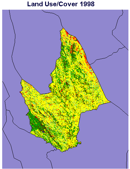 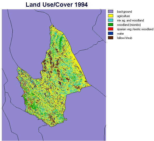 |
Briefly, these preliminary results show an overall decrease in the combined categories of "mixed agriculture with woodlands" and "woodlands" from 35% to 28% between the time periods. Of note, the "mixed agriculture with woodlands" from 1994 has dominantly become agriculture by 1998. Additionally, the area to the northwest of Mpira dam has experienced significant reforestation following the imposed watershed management of the area, which included the eviction of farming activities from this area. These initial maps will be ground truthed and further improved in the coming months. Additionally, the 1984 image will be classified with the assistance of aerial photography.
Annex 3: Site selection
Nsipe is an EPA that is made up of 162 villages each of them located within one of the 12 Sections for agricultural purposes. Nsipe EPA is part of the Ntcheu Rural Development Project. The EPA has a population of 23 675 people [(with 5.66 persons per farm family). It has an area of 80000 ha of which 19000 ha are arable. Of the 12 sections 8 are manned (and 4 are not due to budgetary constraints) by Field Assistants who partly oversee the work of 800 tobacco clubs. For extension purposes each section is divided into Blocks.
Village Selection Exploratory Meeting of EPA officials
Issues related to land use and cover change (individual observations)
Village Selection
A total of 4 villages were proposed for each criterion and a rural rapid appraisal system used to determine the most likely site. Use was made of crop production figures provided by the agricultural department.
1. Reduced livelihood security (as in reduced nutritional status of children)
Villages identified Kanjati (Mpira section), Dambo (Chitungu section), Ntsitsamayi (Mpira section), and Machila I (Madzanje section).
Kanjati village was chosen (319 hh of which 143 are MHH and 176 are female headed. The village was noted for low agricultural production, poor club formation, and low requests for assistance from extension workers. Further the Nsipe Health Center and CARITAS confirmed that food availability in this village was a problem as they have been running supplementary feeding schemes in this village since 1993.
2. Encroachment and/or conversion of State Forest Reserves
Kasale 1 and 2 (Mpira section), Gomeza, Chimukuluchina (Mpira section). This section borders with the Mvai Forest Reserve.
Kasale 1 and 2 villages were selected and between them they have 336 households of 140 (41.7%) are male headed. Two village were combined because of their proximity to each other and the changes on the boundary of Mvai Forest Reserve as well as the catchment area of Mpira Dam cannot be understood if one of the two villages is left out.
3. Encroachment and/or conversion of customary forests
A number of villages in the Nsipe EPA still have substantial stands of indigenous woodlands and we are keen to fond out if these have been encroached upon due to agricultural expansion. We started off with the following villages: Khuzi (Dzunje section), Kamiza and Mpando (Mwalawoyera section), and Bunyenga (Makwangwala section).
Khuzi village on the bottom slopes of Dzunje mountain was selected. Encroachment was noted as having taken place and the villagers agree that this ahs taken place but were rather guarded on the reasons for the encroachment. Khuzi has a population of 894 people in 158 households broken down as follows 94 MHH (59.49%) and 64 FHH (40.51%). NB: Mr. Sam Mpasu, Secretary General of the UDF and Minister of Information in the Malawi Government comes from this village)
4. Managed community woodlands
In contrast to the scenario above the team also sought for villages where encroachment on indigenous woodlands has been minimal due to the existence of stringent local woodland management rules. Only three villages fitted this category and they were: Kachimanga (Mpira section), Kawere (Dzunje section), and Chagwamomwe (Madzanje section)
Kachimanga village in the Mpira section selected has a population 1279 people residing in 226 households [54 MHH (23.89%) and 172 MHH(76.11%). Kachimanga is next to Ntcheu town and is on the foot hills of Ntcheu hill. Some efforts have been put into restricting encroachment on the hill as well as general tree conservation. It will be interesting to contrast these efforts with the lucrative offers of cash crops as well as the energy requirements of the urban households in Ntcheu. Consideration should be given to Kawere village (Dzunje section) where a family (not a village) has conserved a small woodland but are now encroaching on it themselves.
That agricultural production has increased cannot be doubted but what effects have higher returns in agriculture had on investments in soil and water conservation. The following villages, Chikomba and Pheza villages (Pheza section), Chinyamula village (Chiole section), Sulo village (Dzunje section) where increased crop production was noted were considered for this category.
Pheza was selected 2173 people in 384 households broken down as follows 322 MHH (83.85%) and FHH (16.15%). This village shares a boundary with an Estate and shows remarkable increases in burley tobacco production as well as significant requests for conservation works. It is our belief that not all the farmers are adopting conservation works and therefore we can study both types of farmers in one single village. The question of conservation works applies across the whole study site.
In addition to conservation measures we are also interested in villages where there has been a tremendous inflow of money from cash crops and we want to establish the implications this has had on food production. The following villages were considered: Semu Chimwala (Mwelawoyera section), Pheza village (Pheza), Zidana and Muyeyano (Nsipe section)
Semu Chimwala was chosen 758 people in 134 households (52 MHH (38.81%) and 82 FHH (61.19%). The situation in this village was summed up nicely by the Village Headman during the village meeting, "You farmers go to Lilongwe to collect your thousands of Kwacha for tobacco and are proud of that yet you no longer produce chimanga (maize) anymore. You are reducing us to a village of beggars". Sitting on sandy loam soils the village exhibits signs of being a tobacco village. Almost every household in Semu Chimwala has a tobacco shed and it has one of the oldest tobacco growing groups in the EPA. At the time of the meeting the sheds were being repaired and the nurseries in place. But the key question is where is all the newly found wealth going?
Nsipe EPA 4 Study: Survey Instrument
Name of Enumerator _________________ Village ________________
Headman ____________________ Traditional Authority ________________
Section A: Household Profile
A1 Name of respondent_______________________
A2 Sex of Respondent (circle one) Male/Female
A3 Head of Household (circle one) Male/Female
A4 Ethnic group _____________ A5 Religious affiliation _________
A5 Was Head of household born in this village? Yes/No (circle one)
A6 If the answer to A5 is No why did they come to the village?
A7 Where did they come from?
_______________________________________
A8 Who allocated the "plot/stand"?___________________________
A10 Which village organizations does the head of household belong to? (list)
A12 Which of these influences land use decisions most?
A11 How many household members normally reside in this household?
|
Column 1 |
2 |
3 |
4 |
5 |
|
Name of H/H Member |
Relation to H/H Head |
Sex |
Age |
Occupation |
Section B: Natural Resources Base: Land
B1 Who usually allocates land in this village? _________________________
B2 Types of lands allocated to the household.
|
Land type |
Land use |
Main reason for acquisition |
When allocated |
How long |
Allocated by |
Rights |
B3 Has the head of household ever extended arable land since 1994? Yes/No
B4 If Yes, why
B5 Is the land you currently work on adequate for you and your family’s basic food security? Yes/No
Give reasons
Section C: Buildings
C1 Has the household built a tobacco shed for its own use?
C2 Does the household share the use of a tobacco shed?
C3 Has the household been involved in the construction of a building other than a house in the last 4 years?
C4 If Yes, what type of building and where did the money come from?
C5 Has the household purchased equipment (other than a hoe) in the last 4 years?
C 6 If Yes, what and where did the money come from?
Section D: Household Economy
D1 What are the household’s main sources of income? (list and indicate gender of person responsibility)
D2 Of these which contributes the greatest percentage of the income?
D3 What are the household’s other sources of income
D4 What does the household spend its money on?
D5 Do you use hired labor?
D6 If so, for how many people weeks?
Section E: Crops
E1 Crops grown in 1997/98 season
|
Crop |
Purpose |
Yield |
Percent Sold |
Income Earned |
Seed Source |
Fertility Mangmnt |
Controlled by (M/F) |
E2 What problems are faced in crop production?
E3 What are you actually doing about the problem?
E4 Do you have access to credit?
Yes/no
E5 If yes, from whom?
E6 Have you applied any soil conservation or improvement measures to your arable lands?
E7 Which ones, and which do you consider as most effective?
Section F: Livestock Ownership
F1 Animals in household.
|
Animal Type |
Number |
Owner (M/F) |
How Obtained |
ash, Draft, or Subsistence |
Section G: Natural resources Base: Woodlands and Grazing
G1 What woodland products does the household use? (List)
G2 Are your need related to woodlands products satisfied
Yes/No
G2 If no, why is this the case?
G3 Do you have any sacred woodlands?
Yes/No
G4 If yes, what is their importance?
G5 What are the main sources of firewood used by your household?
G6 Is the grazing available to you adequate?
Yes/no
Section H: Natural resources Base: Water
H1 Indicate source of water for household use
H2 Is the amount of water adequate for household use?
Section I: Sources of Information
I1 Which organizations extend resource management information to the household? (List)
I2 How aware were you of the change in national policy towards market liberalization?
Section J: Change
J1 Have you noticed any changes in the woodlands (in last 5 years)?
J2 In what ways (good or bad) have these changes in woodlands affected the household?
J3 What did you think are the reasons for these changes?
J4 How have you addressed these changes as an individual?
J5 How have you addressed these changes as a community?
J6 Have you noticed any changes in the soils (in last 5 years)?
J7 In what ways (good or bad) have these changes in soil affected the household?
J8 What did you think are the reasons for these changes?
J9 How have you addressed these changes as an individual?
J10 How have you addressed these changes as a community?
J11 Have you noticed any changes in the potable water (in last 5 years)?
J12 In what ways (good or bad) have these changes in water affected the household?
J13 What did you think are the reasons for these changes?
J14 How have you addressed these changes as an individual?
J15 How have you addressed these changes as a community?
J16 Five years ago did the food you produced last throughout the year?
J17 Has there been any change in the amount of food you produce since 5 years ago?
J18 These days are you relying more or less on tubers and roots to feed your family
(as compared to 5 years ago)?
J19 These days are you purchasing more food than 5 years ago? Why?
J20 If yes, do you prefer this strategy over producing your own food?
J21 If No, then why do you continue to grow cash crops?
J22 What overall affects have market liberalization had on your household?
J23 Have these affects been beneficial to your household or not? In what ways?
J24 Do you think that market liberalization has enhance your household food security?
J25 Has market liberalization increased the available cash in your household?
J26 If yes, how is this money spent? (list/describe)
J27 Has market liberalization affected the way decisions are made in the community?
J28 How has market liberalization affected natural resources?
J29 Has market liberalization caused any conflicts concerning the use of natural resources? List types of conflicts between households/communities, villages.
J30 What is being done to resolve these conflicts?
J31 What changes have you noticed in conservation laws and their enforcement?
Section K: Future
K1 5 years from now, what do you expect the natural resources to be like?
K2 5 years from now, do you think your food security will be increased or decreased?
K3 If you expect a decrease, what are you going to do about it?
K4 What role do you think the government has to ensure food security?
K5 In the future, what role do you think the government should have in managing local woodlands?