
|
|
|
MEMP Homepage |
Draft Report on the Effect of Market Liberalization On Erosion in the Nsipe Extension Planning Area (EPA), MalawiBy Howard Evan Canfield
|
Executive Summary
This report describes the findings of a qualitative soil erosion assessment for the Nsipe EPA in Ntcheu RDA, Malawi. It presents the findings as a somewhat relative comparison to other areas of Malawi. The National Environmental Action Plan (NEAP) for Malawi identified soil erosion and sedimentation as the most important environmental problem.
The objective of the assessment was to be able to estimate the effect of market liberalization on erosion in the Nsipe EPA. Market liberalization began in 1991, but did not begin in earnest until 1994. It was hoped that it would be possible to attribute changes recognized in the field to market liberalization. The effect of tobacco on erosion was a particular interest. This is not only because erosion is thought to be worse under tobacco than other crops, but also because more pesticides would be used on tobacco than other crops, and with erosion, more of this might move into the environment.
Area under crop production did appear to increase in recent years. Furthermore, there was an increase in crops that could be used for cash cropping. Also, in many areas, farmers stated that uplands of the watershed had been cleared in recent years. However, it was clear from field observation and conversations with farmers in the EPA that drought in three of four years in the early 1990s had a marked effect on their planting and conservation strategies. Furthermore, while there appeared to be some overall degradation of watersheds in the EPA, with a general decline in water tables, a sustained drought can deplete ground water resources. As such, it is not clear how much of the degradation can be attributed to actions of the people in response to policy change, and how much can be blamed on the whims of nature.
Using the data on areas planted in different crops, it was possible to show that there would be an estimated 10% increase in soil erosion from agricultural lands all else being equal. Most of this is attributed to a 16% increase in cropping area between 1994 and 1998. Field observation suggests that some of the new land coming into cultivation was in steeper than average slopes. However, better conservation practices have been more widely adopted in recent years. Therefore, a 10% increase in soil erosion from agricultural areas can probably be viewed as a conservative estimate.
Interestingly, while tobacco is commonly thought to be a crop with poor soil protection characteristics, it appears that erosion under tobacco is no worse than under maize, because of the relatively poor yields in maize, good tobacco yield, and higher ridging used for tobacco.
I. Introduction
A. Background:
The Malawi Environmental Monitoring Programme (MEMP) has an objective to help monitor the effect of environmental change. Since soil erosion and sedimentation has been recognized as by the National Enviornmental Action Plan (NEAP) as a particular area of interest, MEMP has focused some of its activities on improving erosion prediction technology in Malawi by doing small plot studies.
In addition, since the Government of Malawi (GOM) is interested in the effect of policy change on the environment, there was an interest in trying to estimate the effect of market liberalization on erosion. While there is a need to estimate soil erosion in Malawi, prediction technology typically is incapable of producing quantitative estimates at the scale necessary to plan. For this reason, an EPA (Extension Planning Area) was selected as a scale at which to attempt to understand soil erosion. In this case, only readily-available data were used in conjunction with field appraisal to make an assessment of the potential soil erosion hazard.
The Nsipe EPA was selected in the Ntcheu RDP (Rural Development Project) because other USAID projects currently are working there. These include the Small Agribusiness Development Programme (SADP, through ACDI) and the Malawi Agroforestry .. (MAFE). It is also an important location because it is at the headwaters of the Rivi Rivi river basin which is thought to account for some of the sedimentation problems in the middle Shire River.
B. Objective
The objective of this work is to attempt to describe the change in erosion hazard associated with market liberalization.
C. Scope
The scope of this work included the following:
This report describes the following:
II. Nsipe Physical Environment
Nsipe is a heterogeneous EPA in geomorphology, soil type, cropping practices and village layout. Virtually all soils in the EPA are derived from in place weathering of felsic and intermediate igneous and metamorphic rock. As such, most of the soils are not highly fertile, and so farmers choose to leave land fallow at extended intervals when yields begin to decline.
Soil texture varies between clay and sand with a very limited amount of loamy soil. Erosion hazard appears to be high throughout the EPA. Severe gullying can be recognized in virtually every village. In the more hilly regions to the eastern and western edge of the EPA, soils are very thin with bedrock commonly outcropping.. Furthermore, many of the channels show signs of sedimentation. Therefore, there are many indicators of erosion and sedimentation throughout the EPA.
The relative damage from gullying is dependent on soil type. More cohesive soils such as the lithosols that occur in Nsipe, are less likely to erode by flowing water. However, once gullying has begun, the sides of the gullies tend to be vertical. These vertical sides are not stable, and are subject to mass wasting processes. This is accentuated by the fact that in the clay rich soils, water that has infiltrated tends to move laterally discharging into the gully. Therefore, some of the worst gullying occurs in areas with soils that do not have inherently high soil erodibility.
Because the environment is relatively humid, drainages become ground water discharge points for water infiltrated on hillslopes. In most drainages, a wetland (dambo) develops. In some of the drainages, true channels are not present because the drainages are very wide with extensive peat-rich soils.
In areas where the dambos are sufficiently dry, they are cultivated with vegetables and other high value crops. However, food security crops may also be grown in the dambo, because crops can be planted earlier in the growing season. Most of the cropping, however, is done in other parts of the watershed. The land percieved as the most fertile soil changes from location to location, so that in some cases, more land is cultivated on the uplands, and in others, more is cultivated on the hillslopes.
In the central part of Nsipe, slopes are typically less than 6%, while in the more hilly regions to the east and west, slopes over 20% are being farmed. While, it would appear that the more hilly regions are more marginal lands for agriculture, most of the villages are generations old, according to villagers and the Development Officer (D.O.).
In fact, throughout Nsipe, villages have been settled for a very long time. This is in contrast to other EPAs where new villages have been settled in recent years as population pressure forces villagers to settle previously uncultivated areas. Furthermore, in some villages houses are spread throughout the village holdings, while in other areas houses are centralized. The fact that Nsipe has been settled for such a long time means that a vast majority of the arable land has been farmed at one point or another. Typically villages in hilly areas seem to have more long-term fallow land than villages in the more central, flatter regions.
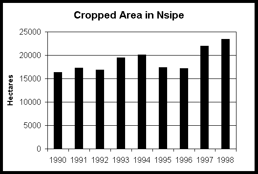
Crop production figures suggest that cropping areas in Nsipe have increased only minimally since 1990. Change in total cropping area through time is given in Figure 1. There appears to have been a moderate increase in the past couple of years, with the total cropping area holding about steady prior to that point. Since approximately 20,000 ha of the 80,000 ha in the EPA are actively cropped in a year, only about 25% of the land is in crops in any given year.
In addition to cropped areas, there are areas of extended fallow in most villages which account for most of the land not currently in production. In some villages, this may be more than half of the village holdings, while other villages may have only a small amount of fallow land. Because each year some of the fallow land is going into production and other land is being taken out of production, it is not clear by visual inspection whether total land in production is increasing or decreasing.
All villages cultivate maize (usually both hybrid and local varieties). Casava, tomatoes, cabbage, onion, beans, sweet potatoes, white potatoes, and eggplant are widely cultivated for food and cash. In addition, tobacco, paparika and sunflower are grown as cash crops. Mango trees are widely planted, and citrus has been planted to a lesser degree. The historical data for cropping areas in each of these crops is given in Table 1. (Note that some of the crops observed in the field were not recognized in the available historical data.)
The data in Table 1 show a steady decrease in the area planted in local maize. While in recent years, more hybrid maize is being planted, there has been an increase in cash crops such as tobacco, and crops that are both eaten and sold such as beans. There has also been a steady increase in millet production, though the reason is not clear.
Figure 1
 |
Source: Famine Early Warning System (FEWS) data base.
Data were collected by Field Assistants based on measurement of cropping areas for 6 farmers in each of 12 sections within the EPA (i.e. field sample of 72 farmers per year).
TABLE 1
The mean annual rainfall in Nsipe is approximately 1000 mm/yr. However, three non-recording rain guages are present in the EPA, and spatial variability of rainfall may be significant. For example, in 1991, a regional drought occurred all over southern Africa. The primary rain guage used (town of Ntcheu), showed seasonal rainfall of 744 mm which was slightly below normal, but in the areas away from the rain guage, rain was slight. . Furthermore, the average of three non-recording rain guages on the EPA showed 1993/1994 season rainfall of 451 mm, and succeeding year in 1994/1995 where only 527 mm fell. Therefore, in three of four years significant drought occurred. Even during the 1997/1998
growing season, a shortage of rainfall during the flowering stage of maize caused poor yields for some farmers in Nsipe.
III. Effect of Changes in Cropping Pattern on Erosion
To test the effect of market liberalization on sediment loss in Nsipe, soil loss was estimated in 1993/1994, the last year before market liberalization, and 1997/1998. Since some crops provide better soil protection for erosion, it was thought that it might be possible to compare the predicted soil loss from crops planted in 1993/1994 to those planted last year. Evaluation of the data suggests that cropping patterns made negligible difference in the sediment lost per hectare. However, the total sediment lost was 10 % greater in 1998 than in 1994 because of the relative increase in cropping areas.
The SLEMSA model was used to estimate the soil loss. A discussion of the feasibility of applying SLEMSA in Malawi is described in Appendix A. While there are a number of possible problems with applying the SLEMSA model in Malawi, perhaps the most important problem is that it is a regression relationship developed in a country which typically has less rain than Malawi. Some areas in Malawi receive almost 2000 mm a year of rain, while the test plots in Zimbabwe that were used to develop SLEMSA received less than 1000 mm. As such, extending the relationship to Malawi requires verifying the total rainfall depth to rainfall energy relationship at a minimum. However, it should in fact be verified with field trials in areas of Malawi that get more rainfall.
The calculation of soil loss is summarized in Applendix B. The relatively high soil loss predicted is caused by the relative steep slopes (assume an average of 6% slopes for the EPA), and the relatively poor cover provided by the crops. This is because yields are low for maize, which means that maize cannot protect the soil as well as it might if yields were greater. In contrast, the tobacco yield data suggests that Tobacco yields are relatively high. As such, the estimated cover provided by the tobacco is actually better than the protection provided by poor yielding local maize.
This is particularly interesting because Elwell ( ) says that tobacco provides a canopy with poor soil protection characteristics. However, if tobacco yields are relatively good, as in Nsipe, and maize yields are poor, the tobacco can provide a better cover. It is also interesting to note that ground nuts provide a particularly good plant canopy cover. As such, the increased area planted in ground nuts in 1998 vs. 1994 is responsible for much of the reduction in erosion rates per hectare.
The negative impact of the poor canopy cover for tobacco is somewhat offset by the cultivation practices for tobacco. For example, ridging for tobacco is typically higher for tobacco than for maize. According to the D.O., this is in order to accommodate the deeper root structure for tobacco. Trials carried out at the MEMP test plots suggest that at relatively shallow gradients, the deeper ridging for tobacco somewhat offsets the effect of poorer canopy cover for tobacco (Mkandewere, 1997). However, this effect is not quantifiable for other conditions.
In addition, there are some qualitative observations regarding cultivation practices and tobacco vs. local maize that may have an effect on soil erosion. Typically farmer provide extra manure and organic matter to improve yields. In fact the relatively good yields for tobacco in Nsipe may be attributed to this practice. Since organic matter improves the infiltration and cohesion characteristics of the soil, this may further reduce erosion under tobacco. However, for farmers with limited resources, putting more manure under tobacco may leave less manure for the remainder of the crops. Therefore, the relative reduction in soil erosion hazard under tobacco may be offset by increased soil erosion hazard under maize, for example.
IV. Changes in Conservation Practice
Relatively good soil conservation is practiced in Nsipe, however, it appears that most of these measures are aimed at improving water conservation rather than soil conservation. In Malawi, only about 12% of the contour ridges are located along contour. In Nsipe, most fields have contour ridges that are approximately on contour. In addition, tied ridges appear to be used in over half of the fields. In some villages virtually all fields will have tied ridges, while in others, there will be no tied ridges at all.
Tied ridges are a good conservation measure, because they prevent the water from flowing down the ridge and out of the system. Furthermore, since ties are typically less than 10 m apart, if water does flow down the ridge, it will typically not gain enough force to break ties. In addition, because land holdings are small, and fields are cultivated by human labor rather than machines, paths exist between fields. These paths are typically located perpendicular to ridges, which means that paths often run from the top of the slope to the bottom of the slope. In areas without tied ridges, water may flow down the furrow between the ridges, and then down the path between the fields. This often results in gullying along the path.
While the soil conservation benefits of using tied ridges are clear, most farmers interviewed said that they adopted tied ridges for water conservation after the very dry years of the early 1990s. Tied ridges are practiced even in flat areas with shallow slopes, while they appear to be less common on some of the steeper slopes on the western edge of the watershed. In fact, these areas are thought to get slightly more rain, and more frequent rain in the higher elevations. The fact that the tied ridges are most important as a water conservation method rather than a soil conservation method is further supported by the fact that they may be practiced in villages with large fallow areas which may not need to be as concerned as a
The D.O. has stated that the Land Resources Department has been trying to encourage tied ridges for many years, but most farmers interviewed said that they adopted tied ridges only in the recent few years. In fact, there are very few farmers who claim to have always used tied ridges. The technology appears to have been in place for at least 20 years. However, many villagers said that they first used tied ridges in the 1995/1996 growing season.
The type of tied ridges being practiced by farmers is different than the types of tied ridges advocated by the D.O. The D.O. advocates the use of staggered ties every two meters, so that the tie in one ridge will be offset one meter from the tie in the next. In fact, the tied ridges practiced by the farmers has a much longer lenghth, and is not staggered.
Another conservation practice which occurs in Nsipe is the planting of Banana trees along drainages and gullies. This is less widely practiced than the tied ridges, but it was present in some of the areas where tied ridges were not used. In general, the banana trees stabilize the banks and slow the flow of water, which in turn improves infiltration and allows the bananas to grow. Discussions with farmers indicated that the bananas had been used in the gullies prior to adoption of the tied ridges.
V. Erosion Hazard and Watershed Degradation
While most attempts to quantify erosion focus on the hillslope scale. It is clear from evaluation of conditions in Nsipe, that the scale of understanding should be the watershed scale. Furthermore, watershed processes including the hydrologic components should be considered in addition to erosion and sedimentation.
The link between hydrology and erosion is best illustrated by processes effecting the wetlands. In most of Nsipe, there are wetlands (dambos) along the main drainages. In a well-forested watershed, the forest tends to slow the movement of water downslope resulting in infiltration of the water. This water then moves laterally underground, and discharges to the dambo. As such, the dambos remain wet most of the year. The soils in the dambo are peat-rich and are without exception the best soils in the watershed.
With deforestation and agricultural development of the uplands, two processes may occur that change the soil and water conservation characteristics of the watershed. First, the removal of vegetation causes infiltration characteristics of the hillslope to decrease, so that more water is available for runoff. Second; more flowing water causes more rilling and gullying which act to better drain the hillslope, and to remove more soil from the hillslope.
On hillslopes, soil can be detached by either raindrop impact or flowing water. As such, conditions which reduce the effects of either detatchment process reduces erosion. Therefore, a more dense plant canopy can reduce the impact of raindrops which reduces erosion. Likewise, water will flow faster on a steeper slope. The longer the slope, the more water will accumulate at the base of the slope. If grass or stubble is present where water is flowing, it tends to slow the water and increase infiltration capacity, reducing the potential for erosion.
With accelerated erosion on hillslopes, the erosive power of water becomes more important. Rills tend to incise on hillslopes and form gullies. Gullies tend to increase the drainage capacity of the watershed. Therefore, during rainfall events more water is drained from the watershed. As such, less water infiltrates into the ground, and less is available for ground water recharge.
Therefore, as practices change on hillslopes, potential for erosion increases, this may lead to accelerated soil erosion and development of gullies. Then, as the gullies further entrench, less water is available for recharge, so that the water table falls. This in-turn leads to drying up of the wetlands (dambos). So, changes in cultivation practices which lead to accelerated soil erosion may have widespread consequences throughout the watershed.
In Nsipe, the condition of the dambos can be described in the following three categories:
A related issue, is that of sediment movement and storage. Under normal hillslope erosion, some sediment is eroded, and the vegetation in the dambo acts as a filter strip so that the sediment gets incorporated into the dambo producing the rich soil in the dambo. However, under accelerated erosion, accelerated sedimentation may occur in the dambo. This is particularly a problem in areas with sandy soils in the uplands (e.g. Namitsitsi Dambo on the eastern edge of Nsipe where sandy soils in the east contribute to sedimentation in the dambo). In some cases, these dambos are degraded to the point of being infertile for crop production.
Therefore, the fact that most of the dambos in Nsipe fit into categories 2 and 3 suggest deteriorating watershed capacity in most of the watersheds of Nsipe. While some possibility exists to improve the capabilities of the category 2 watersheds, category 3 watersheds may be too highly degraded to have feasible watershed reclaimation. Furthermore, category 2 watersheds near sandy soils may also be too highly degraded for reclaimation.
VI. Conclusions
During the period since market liberalization, there appears that there has been an increase in the area of land planted. Furthermore, there appears to be increased erosion hazard from agricultural land associated with this production.
While tobacco is typically a poor cover crop, in this case it appears that tobacco is not a particularly important contributer to the erosion hazard. This is because yields from tobacco are good in Nsipe, while yields of more traditional crops such as maize are poor. As such, while a high yielding maize would typically have a more dense canopy than tobacco, poor yielding maize provides equal or worse canopy cover than the tobacco.
While more land is going into agricultural production according to available data, better conservation methods have also been adopted in recent years, largely to improve water conservation. While the tied ridges conservation technique was known in Nsipe for some time, it has been more widely adopted since the drought years of the early 1990s.
All told the extensive use of the land in Nsipe has cause widespread severe gullying. In the worst cases, gullies may be less than 20m on spacing and as deep as 1 meter. The degradation of the land in conjunction with cutting of trees on some hillslopes has caused widespread watershed degradation as a whole which can most easily be seen in the dambos. Most dambos observed were reported to have declining water levels, in some cases also associated with sedimentation. This has led to loss of production of some of the most fertile land in the EPA.