
|
|
|
MEMP Homepage |
Clark University Activities
|
This report will review Clark’s involvement in Malawi Environmental Monitoring Programme (MEMP) II from February to May, 1998 with reference to tasks as outlined in the Second Annual Workplan for the Components of the Malawi Environmental Monitoring Progamme (MoREA, 1997). During this period Clark University provided technical assistance: in developing digital spatial data standards envisioned to be used as procedural guidelines for the development of digital map data by all sectors of the Government of Malawi; in investigating land cover change and soil erosion in the Shire - an investigation aimed to expose participating agencies to issues in developing a national Environmental Information System (EIS); in investigating the long term acquisition and value of 1km AVHRR data for future environmental monitoring in Malawi; and in providing general technical assistance in the use of geographic technologies for environmental monitoring as requested by line agencies.
Duties of the technical advisors
Three short term technical advisors were involved: Dr. Ronald Eastman (March 10th - March 22nd), Nicholas Haan (February 23rd - April 11th), and Mathilde Snel (February 29th - May 7th). Their duties included:
1) providing technical assistance to the Department of Surveys (DOS) in developing digital mapping standards (task ID 2.4, 2.5, and 2.6 in the Second Annual Workplan for the Components of the Malawi Environmental Monitoring Programme, 1997);
2) preparing and conducting a technical session in soil erosion modeling as part of the Shire investigation (task ID 2.1, 2.2, 2.3, 2,8, 6.3);
3) preparing and conducting a technical session focused on analyzing information compiled to date on land cover change and soil erosion in the Shire as a part of the Shire investigation (task ID 2.3, 2.8, and 6.3);
4) conducting social analysis in "hot spots" of significant land cover change as part of the Shire investigation (task ID 2.3);
5) investigating the application and acquisition of 1km AVHRR data for future environmental monitoring in Malawi (task ID 4.1, 4.2, and 4.3);
6) providing technical assistance in developing a GIS syllabus for an environmental sciences curriculum (task ID 6.5);and
7) providing general technical assistance in the use of geographic technologies for environmental monitoring where requested (task ID 6.3).
Accomplishments of the Technical Advisors
Assistance in the development of digital spatial data standards
The technical advisors Dr. Ronald Eastman and Mathilde Snel provided further technical assistance in developing digital spatial data standards at the Department of Surveys (DOS). While the current discussions have focused on procedures specific to the DOS, the digital spatial data standards are envisioned to be used as procedural guidelines for the development of digital map data by all sectors of the Government of Malawi. Discussions were held on March 13th with Mr. Geshan Gunda, the Chief Staff Surveyor, Mr. Emmanuel Likombola, and Mr. Geoffrey Mzembe on revisions of the digital spatial data standards draft (1997) regarding improved Molendensky constants for Malawi, digital map accuracy calculations, spatial metadata format structure, and a data transfer standard (task ID 2.4, 2.5, and 2.7). A second revision of the Malawi Digital Spatial Data Standard was drafted (see report in Appendix 1 - "Malawi Digital Spatial Data Standard, Version 0.2", Department of Surveys (1998)).
Additional technical assistance was provided by Mathilde Snel on April 29th and April 30th in developing spatial metadata for the 1:50,000 and 1:250,000 digital map sample tiles (respectively about Lisanjali and Liwonde). The digital map tiles will be used as illustrative samples of digital spatial data as they may be distributed in the future by the DOS and other line agencies in Malawi (for more details refer to Snel et al, 1997). To date, digital data for the 1:50,000 digital tile sample has been completed by the DOS. The DOS will over the next months complete the corresponding metadata for the 1:50,000 digital map tile according to the provisional data standards (Department of Surveys, 1998). Furthermore, the DOS plans to complete the digitizing of the 1:250,000 digital sample and its corresponding metadata according to provisional standards over the next couple of months.
Informal discussions were held at the DOS regarding future data archiving of base digital data in developing a national EIS. The DOS is in the process of submitting a budget (to the World Bank) to request funds for additional hardware to be used specifically for digital data archiving (e.g. 1-2 computers). Furthermore, discussions were held on the possibility of scanning spatial data for the future acquisition and archiving of 1:50,000 and 1:250,000 spatial digital data . Photo plates of the 1:50,000 and 1:250,000 map series are unfortunately not separated by feature but by color. The following photo plates are available for all non-metric and some metric 1:50,000 maps and non- metric 1:250,000 maps in Malawi:
1) blue photo plate: includes rivers, river names, lakes, lake names, and marsh symbols;
2) brown photo plate: includes contours (predominantly thin lines although thick lines exists for every 250m contour) and contours labels (note these labels are placed such that they separate contour lines);
3) black photo plate: includes railway track, railway track labels, district roads, district road labels, tracks, track labels, village sites, village names, peaks, and peak labels;
4) green photo plate: includes forest reserve estates, grassland, and scrub areas; and
5) pink photo plate: includes estate boundaries and estate labels
Scanning may be a possibility for contour information - although contour labels between contours would need to be edited - and river information - although river labels and marsh symbols would need to be edited and removed. Scanning roads, villages, railways, forest reserves, and estates will require extensive editing and will most likely be too problematic. The DOS expressed concern in scanning the non-metric vs. the metric 1:50,000 map series considering the present revisions the DOS is undertaking in converting spatial data into metric. It was informally recommended that 1:250,000 maps and/or metric 1:50,000 maps about areas of concern and of high demand could possibly initially be scanned (e.g. areas about the Shire, the Malawi boundary, and Extension Planning Unit areas boundaries, etc.). In addition, the DOS expressed a concern of the sustainability of scanning and proposed to look into the possibility of obtaining scanning equipment at the DOS itself. Considering the long term investment of converting national spatial data into digital format these issues - whether metric vs. non-metric sheets should be scanned, which features should initially be digitized/scanned, and if scanning could be conducted at the DOS - will require further discussion.
In addition to digitizing/scanning spatial data, the DOS expressed continued interest to further archive and georeference the national coverage of Landsat 1984 and 1994 satellite images. Requests to use the data by the Department of Forestry, Ministry of Agriculture, Department of Fisheries, and UNIMA are evident. To date the DOS has archived and georeferenced satellite images in southern Malawi. Arrangements with the University of Arizona Remote Sensing Center have been made to archive on CD all 1984 and 1994 Landsat images for the Government of Malawi.
Technical session on soil erosion modeling
A technical session in soil erosion modeling was conducted form March 23rd to March 27th with technical assistance from Clark University. The technical session was held as a part of the development of Shire investigation on land cover change and soil erosion in the Shire catchment (task 2.1, 2.2., 2.3, 2.8, and 6.3). As described in the EIS Design Team (1997) report the Shire investigation is aimed to expose participating agencies to issues relating to the development of a national EIS ranging from building capacity in environmental monitoring with respect to institutional mandates, to environmental analysis using a collaborative approach involving various agencies. The Soil Erosion Modeling Technical Session was hosted by the Land Resources Conservation Branch Department in Lilongwe. The technical session particularly focused on building capacity in soil erosion modeling at the Ministry of Agriculture but also included participants from other line agencies such as the Department of Forestry, Meteorology Department, and Department of Surveys. Participants of the Soil Erosion Technical Session have been listed below.
Vincent Mkandawire: Land Resources Conservation Department, Lilongwe, Ministry of Agriculture
The technical session focused on soil erosion modeling using the modified Southern Loss Estimation Model for Southern Africa (SLEMSA) for Malawi (Paris, 1991) - a soil erosion erosion model specific to Malawi that combines information on topsoil texture, soil type, slope, rainfall, and landcover. The soil erosion technical session built on data sets compiled by various line agencies for the Shire investigation: land cover by the Department of Forestry; soils by the Department of Surveys, rainfall by the Meteorology Department, and slopes by the Department of Surveys (task ID 2.1,2.2, 2.3, 2.8, and 6.3) (refer to Snel et al, 1997 for more detail). Technical assistance was provided by Mathilde Snel during the five day course in which participants created a soil erosion model for the Blantyre and Machinga ADDs and three select "hot spots" areas indicative of significant land cover change or soil erosion potential (the Lisanjali, Lisungwe, and Rivi-Rivi watersheds). Furthermore, soil erosion models for these areas were created for both 1994 and 1984 to indicate the effect of land cover change on soil erosion. A syllabus of the Soil Erosion Technical Session has been included in Appendix 2. A summary of the steps used for the SLEMSA modeling during the technical session was drafted by Chilombe (1997) (see Appendix 3). Results of the modified SLEMSA consistently indicate an underestimation of soil loss. Additional research is needed to improve the modified SLEMSA soil loss results for Malawi. Rather than indicate actual soil loss (e.g. in tons/ha/growing season), the SLEMSA results were used to indicate soil erosion potential. Results of the technical session have been included in the Preliminary Report on the Shire Investigation (MEMP, 1998 - see the following section on the "Shire Analysis Technical session" or Appendix 5).
Technical Session on Analysis of Land Cover Change and Soil Erosion in the Shire Catchment
A technical session was conducted from April 15th to April 16th to analyze information on land cover change and soil erosion in the Shire catchment as collected to date (task ID 2.3, 2.8, and 6.3). The technical session had two primary goals: 1) to better understand the biophysical changes with regard to land cover change and soil erosion in the Shire catchment as part of the Shire investigation and 2) to expose participating agencies to issues relating to the development of a national EIS (e.g. the need for a collaborative approach involving various line agencies in analyzing environmental data) (EIS Design Team, 1997). The technical session included presentations by line agencies on information that had been compiled to date in the Shire investigation - particularly a presentation by the Department of Forestry on land cover change and Ministry of Agriculture on soil erosion in the Shire catchment. A syllabus of the technical session has been included in Appendix 4. The participants of the Shire Analysis technical session are listed below:
The session resulted in two short reports - one on land cover change and one on soil erosion in the Shire catchment - that were subsequently edited into one joint preliminary report on results collected to date in the Shire investigation (see Appendix 5) (task ID 2.3,2.8, and 6.3). While both the Shire Analysis and Soil Erosion Modeling (as described in the previous section) technical sessions proved to be useful forums for participating line agencies to collaborate and discuss information as compiled to date in the Shire investigation, it is recommended that future environmental analysis forums are more formal (e.g. a small task force of 3-4 individuals) that extend over a longer period of time (e.g. one month). It is envisioned that such a body could meet once every year/two years to write a summary statement on environmental issues of national importance (e.g. a national state of the environment report) or specific environmental issues (e.g. environmental analysis to investigate environmental changes in the Shire). It is envisioned that such a group would require a formal institutional arrangement whereby respective institutions agree to routinely subcontract staff for such annual/biannual environmental analyses.
Social analysis in the Shire Investigation
Social analysis was conducted by Nicholas Haan and two Malawian social scientists - Patrick Jambo of the Department of Forestry and Orpa Kabambe from Bunda College - from March 28th to April 10th in select villages indicative of significant land cover change in the Shire catchment (task ID 2.3). The social analysis investigations to date have been conducted in select villages within the Lisungwe watershed and Neno area. Similar social analysis to investigate the underlying causes of land cover change are required in other villages throughout the Shire catchment so that mitigation strategies may be proposed. Findings to date indicate that underlying causes of landcover change range from charcoal production to the harvesting of nkunguni- a bug used as an important source of protein in some villages (Haan, 1997). The social analysis will continue to rely on the biophysical results - as described in the two previous sections - to locate areas undergoing significant land cover changes and areas of significant soil erosion potential. For more detail on the social analysis results as compiled to date refer to Haan’s trip report (1998) (Appendix 6).
Investigating the application and acquisition of 1km AVHRR data for future environmental monitoring
Further research and discussions were held on the application and acquisition of 1km AVHRR data for national environmental monitoring in Malawi (task ID 4.1, 4.2, and 4.3). Dr. Ron Eastman and Nicholas Haan (1998) continued work on creating an algorithm to help remove cloud cover from 1km AVHRR images. Cloud removal techniques will be critical in the future use of the 1km AVHRR for national environmental monitoring. Informal discussions were held by Mathilde Snel with Harvey Boetsma at the SADC Fisheries project in Senga Bay on the future acquisition of the 1km AVHRR by the Government of Malawi. It was proposed that following the National EIS/Mapping Programme technical session (to be held approximately September/October, 1998) that discussions with the SADC fisheries project, line government ministries, and Clark University are conducted to more formally work out a strategy for the Government of Malawi to acquire, transfer, and archive the national 1km AVHRR data.
GIS syllabus for an environmental studies curriculum development
Nicholas Haan provided assistance to Yusuf Mohammed in proposing a GIS syllabus to be included in the development of an environmental sciences curriculum (task ID 6.5). For more detail with regard to the proposed GIS syllabus refer to Haan’s (1998) trip report.
General technical assistance
Continued general technical assistance was provided by Clark University as requested by agencies (task ID 6.3). This technical assistance included assistance in digitizing in ArcInfo at the Department of Forestry, assistance in ArcView at the Ministry of Agriculture, and assistance in IDRISI in interpolation methods at the Meteorology Department.
Future Activities
A National EIS/Mapping program technical session will be conducted (approximately September/October) to more formally discuss among line agencies that compile spatial data issues pertaining to the development of a national EIS. The technical session will draw on experiences of the Shire investigation to more formally discuss such issues as national digital spatial standards, routine environmental data acquisition, national data archiving, data distribution, and long range funding strategies for national environmental monitoring. More specifically with regard to the Shire investigation, Clark University will continue providing technical assistance to the Shire investigation: technical assistance for social analysis in the Shire investigation will continue to be provided, while additional assistance on biophysical assessments will be provided where requested. During the next trip Clark University will conduct the intermediate/advanced training in geographic technologies.
Bibliography
Department of Surveys, 1997. Malawi Environmental Monitoring Programme: Technical Seminar on Environmental Information Systems. Draft Report and Recommendations. Blantyre, June 1997.
Chilombe, 1998. Draft of Procedures used in SLEMSA (Soil Loss Estimation Model for Southern Africa, Department of Meteorology.
EIS Design Team, 1997. Strategy for an Environmental Information System in Malawi
Haan, 1998. Malawi Trip Report, February - April, 1998. Malawi Environmental Monitoring Programme; Department of Environmental Affairs, Clark Labs.
MOREA, 1997. Second Annual Workplan for the Components of the Malawi Environmental Monitoring: Environmental Monitoring Technologies, Research, and Policy Sub-Programmes.
Paris, 1991. Erosion Hazard Model (modified SLEMSA). Land Resources Evaluation Project, Malawi. Malawi Government Ministry of Agriculture, Land Husbandry Branch.
Snel, M., N. Haan, and R. Eastman, 1997. Clark University Activities, Trip Report, October - December, 1997. Malawi Environmental Monitoring Programme; Department of Environmental Affairs, Clark Labs.
List of Appendices
Appendix 1: Malawi Digital Spatial Data Standard Version 2.0 (Draft Provisional Version, Revision 2, March 1998)
Appendix 2: Syllabus for Soil Erosion Technical Session, March 23rd - 27th, 1998
Appendix 3: Draft report of Chilombe (1998) on Soil Loss Estimation Model for Southern Africa (SLEMSA)
Appendix 4: Syllabus for the Shire Analysis Technical Session, April 15th-16th, 1998
Appendix 5: Preliminary report on the Shire Investigation, April, 1998.
Appendix 6: Haan (1998) trip report
[Please see PDF document for formatted tables]
Preliminary Report on the
Shire Investigation
A collaborative investigation and joint report by the:
May, 1998. Malawi Environmental Programme, Department of Environmental Affairs. With technical assistance provided by Clark University in collaboration with the University of Arizona.
Preliminary Report on the Shire Investigation
INTRODUCTION
The Shire watershed has recurrently been identified as an area of national priority (EIS Design Team, 1997; MOREA, 1997). As one of the most densely populated regions (Figure 1) the catchment has, however, undergone significant environmental degradation including the siltation of the Shire river itself which has resulted in an unstable national electricity supply. The Shire investigation was proposed to provide a situation analysis on environmental degradation in the Shire particularly with regard to land cover change and soil erosion potential (EIS Design Team, 1997; MOREA, 1997). The initial phase of the Shire investigation has focused on analyzing where significant land cover changes and soil erosion potential occur in the Shire catchment. This report will summarize the biophysical results on land cover change and soil erosion that have been compiled in the investigation to date. Subsequent phases of the Shire investigation will concentrate on: 1) further expanding social analysis to better understand why changes in land cover and soil erosion are occurring and 2) disseminating information to end users ranging from government projects (e.g. reforestation and soil conservation projects such as MAFE, microprojects, and PROSCARP) to private companies (e.g. ESCOM and SUCOMA).
METHODOLOGY
A time series analysis was conducted over a thirteen year period (January 1983 to September 1996) using Advanced Very High Radiometer Resolution (AVHRR) images to identify hot spots of significant land cover change in the Shire catchment. The AVHRR time series results indicated that microwatersheds within the Shire catchment experiencing a present decline in vegetative cover (from 1991 to 1996 - see graph in Figure 2) are particularly Lisungwe, Mkurumadzi, and Mwanza (area codes #1 and #2 in Figure 2 – depicted as black/dark areas), while areas indicating a present relative increase in vegetative cover (from 1991 to 1996 - see graph in Figure 2) are particularly the Lisanjali microwatershed and an area to the west of mount Mulanje (areas codes #3 and #4 in Figure 2- depicted as green/light areas) (see Table 1). In the initial phase of the Shire investigation, the Lisungwe and Lisanjali microwatersheds were chosen as two "hot spot" microwatersheds for intensive investigation on land cover change and soil erosion. Furthermore, a third microwatershed - the RiviRivi - was selected for intensive investigation based on Green et. al. (1996) findings that the RiviRivi watershed contributes significantly to sedimentation of the Shire River. Figure 3 indicates the location of the three microwatersheds – the Lisungwe, Lisanjali, and RiviRivi - selected in the Shire investigation for intensive environmental analysis.
In addition to conducting intensive analysis on land cover change and soil erosion potential in the three selected microwatersheds, an extensive analysis of land cover change and soil erosion potential was conducted for the entire Blantyre and Machinga ADDs. The Blantyre and Machinga ADDs were selected as appropriate administrative boundaries within which the majority of the Shire watershed is contained (EIS Design Team, 1997; MOREA, 1997) (see Figure 3 for the Blantyre and ADD boundaries).
Subsequently a summary of the Shire investigation findings to date are listed. This is followed by an index of results – namely tables, graphs, and maps - on land cover change and soil erosion potential in respectively: 1) the Blantyre and Machinga ADDs; 2) the Lisungwe microwatershed; 3) the RiviRivi microwatershed; and 4) the Lisanjali microwatershed. Note that the land cover change assessment for the Blantyre and Machinga ADDs have been based off 1973 and 1991 Swede study land cover maps, while land cover change analysis for the three selected microwatersheds have been based off 1984 and 1994 Landsat land cover results. The soil erosion potential results as included in this report are based off the modified Southern Africa Loss Model for Southern Africa (SLEMSA) for Malawi (Paris, 1990).
RESULTS
A summary of this reports results are as follows:
INDEX OF RESULTS OF THE SHIRE INVESTIGATION AS COMPILED TO DATE
(primarily maps, tables, and graphs)
General information on the Shire watershed
Figure 1: Map on Population Density in the Shire watershed relative to the rest of Malawi.
Figure 2: Map of a time series analysis over a thirteen year highlighting areas of significant land cover change in the Shire watershed.
Figure 3: Map of the Shire watershed (with EPA, microwatershed, and ADD boundaries).
Table 1: A list of areas indicating significant relative decline (deforestation) and increase (relative afforestation) in vegetative cover over a thirteen year period in the Shire Watershed (refer to Figure 3 for geographic locations of the "Area Code").
Blantyre and Machinga ADDs
Land Cover Change Situation analysis of the Blantyre and Machinga ADDs
Figure 4: Map of land cover change in the Blantyre and Machinga ADDs from 1973 – 1991.
Table 2: Extension Planning Areas (EPAs) within which significant deforestation from 1973 to 1991 have taken place/ EPAs in need of afforestation measures in the Blantyre and Machinga ADDs. (refer to Figure 4 for geographic locations of the "Area Code").
Graph 1: Land cover change from 1973 to 1991 in the Blantyre and Machinga ADDs.
Soil Erosion Potential Situation Analysis of the Blantyre and Machinga ADDs
Figure 5: Map of Soil erosion potential in the Blantyre and Machinga ADDs.
Table 3: Extension Planning Areas (EPAs) about areas of high, moderate, and low soil erosion potential within the Blantyre and Machinga ADDs. (refer to Figure 5 for geographic locations of the "Area Code").
Lisungwe Watershed
Land Cover Change Situation Analysis of the Lisungwe microwatershed
Graph 2: Land cover change in the Lisungwe watershed from 1984 to 1994.
Figure 6: Map on Land Cover Change in the Lisungwe watershed from 1984 to 1994.
Table 4: Village areas about which deforestation have taken place from 1984 to 1994/ Villages in need of afforestation measures in the Lisungwe watershed. (refer to Figure 6 for geographic locations of the "Area Code").
Table 5: Village areas about which afforestation have taken place from 1984 to 1994 in the Lisungwe watershed (refer to Figure 6 for geographic locations of the "Area Code").
Soil Erosion Situation Analysis of the Lisungwe microwatershed
Table 6: Soil erosion potential in the Lisungwe watershed relative to the Lisanjali and RiviRivi watersheds.
Table 7: Soil erosion potential change from 1984 to 1994 in the Lisungwe watershed.
Figure 7: Map on Soil Erosion Potential in the Lisungwe watershed.
Table 8: Villages about areas of high soil erosion potential/Villages in needs of soil conservation in the Lisungwe watershed. (refer to Figure 7 for geographic locations of the "Area Code").
Lisanjali Watershed
Land Cover Situation Analysis of the Lisanjali microwatershed
Figure 8: Map of Land Cover Change in the Lisanjali watershed from 1984 to 1994.
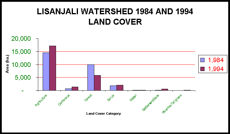
Graph 3: Landcover change in the Lisanjali microwatershed from 1984 to 1994.
Table 9: Villages about areas of significant deforestation/Villages in need of afforestation measures in the Lisanjali watershed from 1984 to 1994(refer to Figure 8 for geographic locations of the "Area Code").
Table 10: Villages about areas of significant afforestation in the Lisanjali watershed from 1984 to 1994 (refer to Figure 8 for geographic locations of the "Area Code").
Soil Erosion Situation Analysis of the Lisanjali microwatershed
Figure 9: Map of Soil erosion potential in the Lisanjali watershed.
Table 11: Villages about areas of high soil erosion potential/Villages in need of soil conservation in the Lisanjali watershed (refer to Figure 9 for geographic locations of the "Area Code").
Table 12: Soil erosion potential change from 1984 to 1994 in the Lisanjali watershed.
RiviRivi Watershed
Land Cover Situation Analysis of the RiviRivi microwatershed
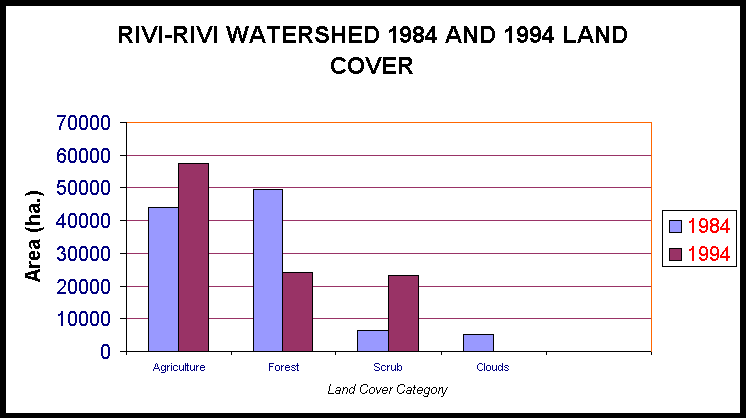
Graph 4: Landcover change in the RiviRivi microwatershed form 1984 to 1994.
Figure 10: Map on Land Cover Change in the RiviRivi watershed from 1984 to 1994.
Table 13: Villages about areas in which deforestation have taken place from 1984 to 1994 in the Rivi-Rivi watershed (refer to Figure 10 for geographic locations of the "Area Code").
Table 14: Village areas about which afforestation have taken place from 1984 to 1994 in the Rivi-Rivi watershed (refer to Figure 10 for geographic locations of the "Area Code").
Soil Erosion Situation Analysis of the RiviRivi microwatershed
Figure 11: Map on Soil Erosion Potential in the RiviRivi watershed.
Table 15: Villages about areas of high soil erosion potential in the RiviRivi watershed (refer to Figure 11 for geographic locations of the "Area Code").
Table 16: Soil erosion potential change from 1984 to 1994 in the RiviRivi watershed.
General information on the Shire watershed
Table 1: Areas indicating significant relative decline (deforestation) and increase (relative afforestation) in vegetative cover in the Shire Watershed over a thirteen year period (refer to the map on Figure 3 for geographic locations of the "Area Code").
|
AREA CODE |
Areas indicative of relative deforestation (BLACK IN FIGURE 2) |
Areas indicative of relative afforestation (GREEN/WHITE IN FIGURE 2) |
AREA CODE |
|
1 |
Lisungwe and Mkurumadzi microwatersheds |
Lisanjali microwatershed |
3 |
|
2 |
Mwanza microwatershed |
Areas to the west of the Mulanje mountain (expansion of tea estates) |
4 |
Blantyre and Machinga ADDs
Land Cover Change Situation analysis
of the Blantyre and Machinga ADDs
Graph 1: Land cover change from 1973 to 1991 in the Blantyre and Machinga ADDs.
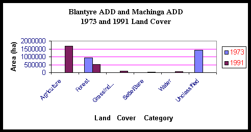 |
Table 2: Extension Planning Areas (EPAs) experiencing significant deforestation from 1973 to 1991/ EPAs in need of afforestation measures in the Blantyre and Machinga ADDs. (refer to the map on Figure 4 for geographic locations of the "Area Code"). (note: this only includes 45% of the entire Blantyre and Machinga ADD area that was classified in both 1973 and 1991)
|
AREA CODE |
EXTENSION PLANNING AREA (EPA) |
|
1 |
Ulongwe, Bazale |
|
2 |
Lisungwe, Phalula, western Chingale, northern Lirangwe |
|
3 |
Neno, Mwanza, Kalambo |
|
4 |
Livunzu,Thyolo Boma |
|
5 |
Nasenga, Mthiramanja, Maiwa |
Blantyre and Machinga ADDs
Soil Erosion Potential Situation Analysis of the Blantyre and Machinga ADDs
Table 3: Extension Planning Areas (EPAs) indicating high, moderate, and low soil erosion potential within the Blantyre and Machinga ADDs. Those EPAs indicating a high potential for soil erosion are in particular need of soil conversation measures (refer to the map on Figure 5 for geographic locations of the "Area Code").
|
Area Code |
Description |
EPAs |
|
1 |
EPAs indicating high soil erosion potential |
Mulanje South, Mulanje West, Thumbwe, Thyolo Boma, Ntonda, Livunzu, Kalambo, Mwanza, Neno, Malosa, and Chingale |
|
2 |
EPAs indicating moderate soil erosion potential that contribute to siltation of the Nkula-Tedzani and Kapichira dams |
Ulongwe, Bazala, Mpilisi, Lisungwe, Ntubwi, Chingale, and Lirangwe |
|
3 |
EPAs indicating low potential for soil erosion |
Mpilipili, Lungwena, Katuli, Ntiya, Maiwa, Mbonechera, Nsama, Mbwadzulu, Mthiramanja, Nasenga, Mitole, and Phalula |
Lisungwe microwatershed
Land Cover Change Situation Analysis of the Lisungwe microwatershed
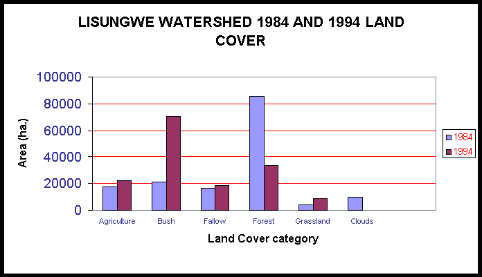 |
Table 4: Village areas about which deforestation have taken place from 1984 to 1994/ Villages in need of afforestation measures in the Lisungwe watershed. (refer to the map on Figure 6 for geographic locations of the "Area Code"). Pressure in these areas generally include deforestation due to population growth, agricultural expansion, and charcoal production. Responses to deforestation generally include a need of afforestation projects particularly about hills and streams, environmental education, and community participatory forest management. Social analysis (as conducted by Haan et al, 1998) is needed to more specifically recommend mitigation strategies.
AREAS INDICATIVE OF DEFORESTATION IN LISUNGWE WATERSHED.
|
AREA CODE |
VILLAGES |
EPA |
NOTES |
|
1 |
Senzani, Njunga, Phingo, Kankao, Ntonda,Matale |
Manjawira |
Area along and around M1 Zalewa Road |
|
2 |
Villages along Mwetang`ombe River and in a Proposed forest Reserve-Mwanza (mostly new villages such as Tiese not presently indicated on the 1:50,000 topo map series) |
Neno |
settlements and agricultural estate expansion |
|
3 |
Hilly areas along Namitani, adjacent Zalewa |
Manjawira |
|
|
4 |
Nkhanya-Lisungwe confluence |
Lisungwe |
Southern part of Nkhanya river |
|
5 |
Chakulembera, Matandani, Kundembo, Msambe, Dzinjiriza, Kabango, Kabvalankwinda – villages in the Tsamba Forest Reserve |
Lisungwe /Manjawira |
Table 5: Village areas about which afforestation have taken place from 1984 to 1994 in the Lisungwe watershed (refer to the map on Figure 6 for geographic locations of the "Area Code").
AREAS INDICATIVE OF AFFORESTATION IN LISUNGWE WATERSHED.
|
AREA CODE |
VILLAGES |
EPA |
NOTES |
|
6 |
Kasamba, Kang`ombe, Ngwenyama, Funsani |
Lisungwe |
Area surrounds Lisungwe river |
Lisungwe microwatershed
Soil Erosion Situation Analysis of the
Lisungwe microwatershed
Table 6: Soil erosion potential in the Lisungwe watershed as compared to the Lisanjali and RiviRivi watersheds (soil erosion potential rates for 1994 expressed as a percentage of the watershed).
|
Soil Erosion Potential Class |
LISUNGWE |
RIVIRIVI |
LISANJALI |
|
Low soil erosion potential |
76.3% |
38.6% |
34.9% |
|
Moderate soil erosion potential |
19.5% |
46.5% |
53.1% |
|
High soil erosion potential |
3% |
11.1% |
11.6% |
|
Unclassified (n/a) |
1.2% |
3.8% |
0.4% |
Table 7: Soil erosion potential change from 1984 to 1994 in the Lisungwe watershed.
|
Soil Erosion Potential Class |
1984 Soil Erosion Potential |
1994 Soil Erosion Potential |
% change in soil erosion potential from 1984 to 1994 |
|
Low soil erosion potential |
122447 ha. (79.3%) |
117617 ha. (76.3%) |
- 3% |
|
Moderate soil erosion potential |
18724 ha. (12.2%) |
30075 ha. (19.5%) |
+ 7.3% |
|
High soil erosion potential |
1978 ha. (1.2%) |
4793 ha. (3%) |
+ 1.8% |
|
Unclassified (n/a) |
11135 ha. (7.2%) |
1803 ha. (1.2%) |
N/a |
Table 8: Villages about areas of high soil erosion potential/Villages in needs of soil conservation in the Lisungwe watershed. (refer to the map on Figure 7 for geographic locations of the "Area Code"). Soil erosion pressure in these areas are generally due to agricultural expansion, particularly on marginal lands (e.g on steep slopes and along rivers) and population growth. Responses to the soil erosion generally include a need for soil erosion conservation practices (e.g. contour ridging, vetiver grass, and agroforestry) and environmental education. Social analysis (as conducted by Haan et al, 1998) is needed to more specifically recommend mitigation strategies. Areas of high soil erosion potential in which significant deforestation has taken place (from 1984 to 1994) have been indicated in italic font.
AREAS INDICATIVE OF HIGH SOIL EROSION POENTIAL
IN THE LISUNGWE WATERSHED
|
AREA CODE |
VILLAGES |
EPA |
|
1 |
Katloeza, Selemani, Chinchembere, Samusoni
|
Lisungwe |
|
2 |
Chiembekeza, Moffatti, Tsamba, Kumbwani
|
Neno |
|
3 |
no villages within area |
Manjawira |
|
4 |
Dzonze, Cabwera, Kandoma |
Tsangano |
Lisanjali microwatershed
Land Cover Situation Analysis of the
Lisanjali microwatershed
Graph 3: Landcover change in the Lisanjali microwatershed form 1984 to 1994.
 |
Lisanjali microwatershed
Table 9: Villages about areas of significant deforestation from 1984 to 1994/Villages in need of afforestation measures in the Lisanjali watershed (refer to the map on Figure 8 for locations of "Area Code"). Pressure in these areas generally include deforestation due to population growth, agricultural expansion, and charcoal production. Responses to the deforestation generally include a need of afforestation projects particularly about hills and streams, environmental education, and community participatory forest management. Social analysis (as conducted by Haan et al, 1998) is needed to more specifically recommend mitigation strategies.
AREAS INDICATIVE OF DEFORESTATION IN LISANJALI WATERSHED
|
AREA CODE |
VILLAGES |
EPA |
NOTES |
|
1 |
Chisinkha , Matipani, Pimbi, Mchela, Chathinachinga |
Phalula /Mpilisi |
Area around Rivi-Rivi / Shire river confluence |
|
2 |
Masula, Kazembe, Kandionanji, Chikonde, Mitawa2, Basikolo, Mtambo, Whisky, Bwanausi, Chibwana |
Chingale |
Along Linthipe dambo |
|
3 |
Mthumba, Wilson |
Ntubwi |
Along M1 road and in Chnduzi hill part of Liwonde Forest Reserve |
|
4 |
Ndaje Nkula, Machinga Boma, Lipongo, Mkalawire. |
Ntubwi |
Around Machinga Boma |
|
5 |
Kwilapo, M`dele, Chinkwenzule, Michongwe, Mdoka, Kwiteuka, Mikundi, Matola, Moto, Mchisa, Makunganya, Matandika, Salimu, Katuli2, Mkasala, Mkawa2, aachimatiro |
Malosa |
Along Malosa Mtn slopes |
|
6 |
Kasonga, Mbuliwa, Malonga, M`bawa, Chilasanje, Domasi |
Malosa |
Along Domasi dambo |
Lisanjali microwatershed
Table 10: Village areas about areas of significant afforestation in the Lisanjali watershed from 1984 to 1994 (refer to the map on Figure 8 for geographic locations of the "Area Code").
AREAS INDICATIVE OF AFFORESTATION IN LISANJALI WATERSHED
|
AREA CODE |
VILLAGES |
EPA |
NOTES |
|
|
7 |
North west part of Malosa F.R. |
Malosa |
Indication of successful implementation of Wood Energy project (ZCGP) |
|
|
8 |
Around Mberekezi hills in Liwonde F.R. |
Ntubwi |
Indication of successful implementation of Wood Energy project (ZCGP) |
|
|
9 |
Tobacco Estate Ltd, Kalambo |
Mpilisi |
Tobacco farming seized some years ago |
|
Lisanjali microwatershed
Soil Erosion Situation Analysis of the
Lisanjali microwatershed
Table 11: Villages about areas of high soil erosion potential/Villages in need of soil conservation in the Lisanjali watershed (refer to the map on Figure 9 for geographic locations of the "Area Code"). Soil erosion pressure in these areas are generally due to agricultural expansion, particularly on marginal lands (e.g on steep slopes and along rivers) and population growth. Responses to the soil erosion generally include a need for soil erosion conservation practices (e.g. contour ridging, vetiver grass, and agroforestry) and environmental education. Social analysis (as conducted by Haan et al, 1998) is needed to more specifically recommend mitigation strategies. Areas of high soil erosion potential in which significant deforestation has taken place (from 1984 to 1994) have been indicated in italic font.
AREAS INDICATIVE OF HIGH SOIL EROSION POENTIAL IN THE LISUNGWE WATERSHED
|
AREA CODE |
VILLAGES |
NOTES |
|
1 |
Kwilapo, M’dele, Chinkwenzule, Michongwe, Chisanje, Moloka, Dwiteuda, Mikundi, Matola, Moto, Mchisa Makunganya, Matandika, Salimu Katuli2, Mkasala, Majambe, Chingenga, Makasala, Chiunda2
|
Between the road running north-south through the Lisanjali watershed and Zomba/Malosa mountain western slopes. |
|
2 |
Mthumba |
Between Liwonde Forest Reserve and Mangolwe hills |
|
3 |
Mkwanba, Makwangwala, Bifa Salifu, Sabuni, Matunda |
North-west of the Piemonpe and Namitembo Estates |
|
4 |
Mbewe, Pimbi, Matipani, Chisinkha, Thundu, Namweta II, Jiya |
Outside the Lisanjali watershed, at the confluence of the Rivi-Rivi and Shire rivers |
Table 12: Soil erosion potential change from 1984 to 1994 in the Lisanjali watershed.
|
Soil Erosion Potential Class |
1984 Soil Erosion Potential |
1994 Soil Erosion Potential |
% change in soil erosion potential from 1973 to 1991 |
|
Low soil erosion potential |
9498ha. (34.9%) |
6579 ha. (24.1%) |
- 10.8% |
|
Moderate soil erosion potential |
14432 ha. (53.1%) |
16194 ha. (59.5%) |
+ 6.4% |
|
High soil erosion potential |
3162 ha. (11.6%) |
4320 ha. (15.8%) |
+4.2% |
|
Unclassified (n/a) |
114 ha. (0.4%) |
114 ha. (0.4%) |
N/a |
Rivi-Rivi microwatershed
Land Cover Situation Analysis of the Rivi-Rivi microwatershed
Graph 4: Landcover change in the Rivi-Rivi microwatershed form 1984 to 1994.
 |
Rivi-Rivi microwatershed
Table 13: Village areas about which deforestation have taken place from 1984 to 1994/ Villages in need of afforestation measures in the Rivi-Rivi watershed (refer to the map on Figure 10 for geographic locations of the "Area Code"). Pressure in these areas generally include deforestation due to population growth, agricultural expansion, and charcoal production. Responses to the deforestation generally include a need of afforestation projects particularly about hills and streams, environmental education, and community participatory forest management. Social analysis (as conducted by Haan et al, 1998) is needed to more specifically recommend mitigation strategies.
AREAS INDICATIVE OF DEFORESTATION IN RIVIRIVI WATERSHED.
|
AREA CODE |
VILLAGES |
EPA
|
NOTES |
|
1 |
Magombo, Nambuya,Ositeni, Bilira, Mkutumula, Chindazi, Pulumuka, Chiwisa, Binoni, Balaka Market, Msiyaludzu
|
Bilira/ Bazale |
All the villages are to the north of M1 Zalewa Road |
|
2 |
Chamthunya, Phingo, Manjawira |
Bazale |
South west of Kamzati market, & School |
|
3 |
Joni, Mwansambe, Zidana, Mpalale, Malota, Hauya, Faiti, Nsenjere, Kamwamba, Seselu, Wandawanda, Kainga, Chisamba |
Manjawira |
|
|
4 |
Chinyamula |
Nsipe |
South west of Ntcheu boma |
|
5 |
Dzunje, Njolinjo, Chanya, Zidana, Mkwezalamba, Njuya, Kawele |
Nsipe |
Rivi-Rivi microwatershed
Table 14: Village areas about which afforestation have taken place from 1984 to 1994 in the Rivi-Rivi watershed (refer to the map on Figure 10 for geographic locations of the "Area Code").
AREAS INDICATIVE OF AFFORESTATION IN RIVIRIVI WATERSHED.
|
AREA CODE |
VILLAGES |
NOTES |
|
6 |
Chikuse, Kasale, Kafetula, Jalasi, Chinkuluchira, Chinkanda, Visenti, Chikondanji, Howa, Chibondo |
This area surrounds Mvai Forest Reserve |
|
7 |
Chakudza, Nenani, Ntendele, Mbirintengerenji, Jenya, Kamuze, Beni-Ngolombe, Kalonga and Kambilonjo |
This area is arround Nzama Mission |
Rivi-Rivi microwatershed
Soil Erosion Situation Analysis of the
Rivi-Rivi microwatershed
Table 15: Villages about areas of high soil erosion potential in the Rivi-Rivi watershed (refer to the map on Figure 11 for geographic locations of the "Area Code"). Soil erosion pressure in these areas are generally due to agricultural expansion, particularly on marginal lands (e.g on steep slopes and along rivers) and population growth. Responses to the soil erosion generally include a need for soil erosion conservation practices (e.g. contour ridging, vetiver grass, and agroforestry) and environmental education. Social analysis (as conducted by Haan et al, 1998) is needed to more specifically recommend mitigation strategies. Areas of high soil erosion potential in which significant deforestation has taken place (from 1984 to 1994) have been indicated in italic font.
AREAS INDICATIVE OF HIGH SOIL EROSION POENTIAL IN THE LISUNGWE WATERSHED
|
AREA CODE |
VILLAGES |
NOTES |
|
1 |
Balaka, Chamathunya, Zamminba, Kapalamula, Amonistute, Matola, Gande, Silivia, Gunde, Jemusi, Alasala, Mberongwa, Balaka Market, Matole, Jemusi, Sabwera, Mpezeni, Sosola, Mponda, Kapalamula, Chinjeni, Chimutu, Gumbi, Njopilo, Kadondo, Lupanga, Kabuthu, Madyelatu, Balaka
|
West of Balaka |
|
2 |
Sande, Muyenda, Kalimeryira, Machenga |
North of Balaka market |
|
3 |
Madeya, Londalonda, Kam’mwamba, Tsikulamowa, |
South of Kumwnji/ Livilidzi estate, west of RiviRivi estate |
|
4 |
Chinkutuchina, Kabwane, Chinkondenii, ChinkandaIII, Chinkandai, Jalasi, Kufetula |
South-east of Ntcheu, north of Mwai forest reserve |
|
5 |
Chipusile, Kamuzeni, Kaisa, KamuzeniII, |
South-east of Ntcheu |
Rivi-Rivi microwatershed
Table 16: Soil erosion potential change from 1984 to 1994 in the Rivi-Rivi watershed.
|
Soil Erosion Potential Class |
1984 Soil Erosion Potential |
1994 Soil Erosion Potential |
% change in soil erosion potential from 1973 to 1991 |
|
Low soil erosion potential |
52533 ha. (50%) |
40499 ha. (38.6%) |
- 11.4% |
|
Moderate soil erosion potential |
34448 ha. (32.9%) |
48764 ha. (46.5%) |
+ 13.6 |
|
High soil erosion potential |
9708 ha. (5.9%) |
11665 ha. (11.1%) |
+ 5.2% |
|
Unclassified (n/a) |
8236 ha. (7.8%) |
3994 ha. (3.8%) |
BIBLIOGRAPHY
EIS Design Team, 1997. Strategy for an Environmental Information System in Malawi. Ministry of Research and Environmental Affairs.
Haan et al, 1997, Trip Report, November – December, 1997. Clark University.
Haan et al, 1998, Trip Report, March – April, 1998. Clark University.
Green, R.I., V. Mkandawire, H. Kandaya, and M. Kapila, 1996. Study to Identify Sources of Siltation in the Middle Shire River Catchment Area. Ministry of Research and Environmental Affairs.
MOREA, 1997. The Second Annual Workplan for the Components of the Malawi Environmental Monitoring Programme: Environmental Monitoring Technologies, Research, And Policy Sub-Programmes.
Paris, S., 1990. Erosion Hazard model (modified SLEMSA). Field Document No. 13 (Second Version). Land Resources Evaluation Project, Malawi.. Malawi Government Ministry of Agriculture Land Husbandry Branch, United National Development Programme, and Food and Agriculture Organization of the United Nations.
Snel, M, N. Haan, and R. Eastman, 1997, Trip report, November – December, 1997. Clark University.
Snel, M, N. Haan and R. Eastman, 1998, Trip report, March – April, 1988. Clark University.