Biosystems Engineering
Welcome to BE
Quick Access


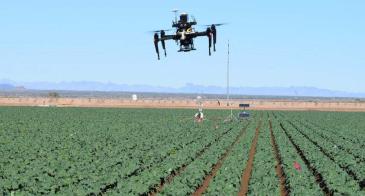
Feeding 9 billion people by 2050!The Biosystems Engineering Department is developing innovative systems to sustainably feed an increasing population through cutting-edge technology, sustainable practices, and the drive to make a difference in the world. We build sustainable solutions that create resilience among society, the environment and the economy. We are also an ideal pre-health track. Biosystems Engineering is currently working on many projects, including the following:
|
Follow us at @BE_UArizona > |