Using geospatial technologies to develop
participatory tools for natural resources management
![]() No.
53, May/June 2003
No.
53, May/June 2003
Using geospatial technologies to develop
participatory tools for natural resources management
|
|
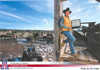
The cover photograph, from the article Participatory
geospatial research and development: Interactive access to spatially dynamic
time-series satellite imagery for natural resources management by Barron
Orr et al., depicts an Arizona rancher holding his laptop computer, symbolizing
his ability to access geospatial information and resource management tools
while working in the field. The Space Grant/Land Grant Geospatial Extension
Service, for which Dr. Orr works, is a program of the Cooperative Extension
Service. Dr. Orr's goal in this program is to create participatory tools
for rangeland management in the western United States. |
![]()
About the Arid Lands Newsletter