Conflict Resolution and Transboundary Water Resources
![]() No. 44, Fall/Winter 1998
No. 44, Fall/Winter 1998
Conflict Resolution and Transboundary Water Resources
| The Zambezi is both a transnational and international river, as these terms are defined in part I of this article. Rising in Zambia, in the Central African Plateau, it initially flows from Zambia into Angola, then back into Zambia. After traversing Zambian territory in a southward direction, it then turns east and forms the international boundaries between Zambia and Namibia and Zambia and Zimbabwe. Entering Mozambique at Luangwa, it flows southeastward across Mozambican territory into the Indian Ocean. The Zambezi drains the entire region of south-central Africa. | 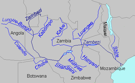 |
Maps copyright Len Milich.
About the Arid Lands Newsletter