Conflict Resolution and Transboundary Water Resources
![]() No. 44, Fall/Winter 1998
No. 44, Fall/Winter 1998
Conflict Resolution and Transboundary Water Resources
| At 2,600 miles (4,200 km) long, the Niger River is the third longest in Africa, after the Nile and the Congo. Rising in Guinea, the river flows northeast into Mali. East of Timbuktu, it bends to the southeast, flowing across western Niger and forming part of the international boundary between Niger and Benin. From there, the Niger enters Nigeria and flows predominantly south, finally entering the Atlantic Ocean through an extensive delta | 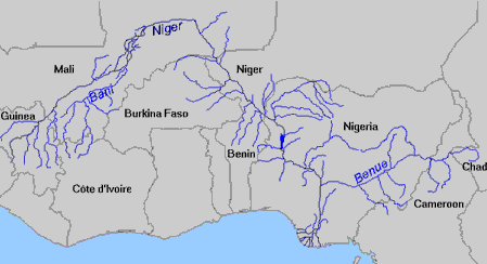 |
Maps copyright Len Milich.
About the Arid Lands Newsletter