Wetland Hydrology
Hydrology is probably the single most important determinant of the establishment and maintenance of specific types of wetlands and wetland processes.
Hydrologic Cycle:
- The hydrology of a wetland creates the unique physicochemical conditions that distinguish it from a well-drained terrestrial system and deepwater aquatic system.
- Hydrologic pathways transport energy and nutrients to and from wetlands via precipitation, surface runoff, groundwater, tides, and flooding rivers.
-
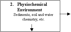
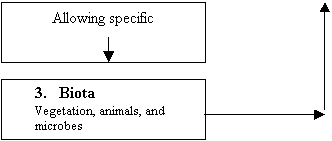
The hydrology of a wetland directly modifies and changes its physicochemical environment. Study of which would be hydrogeomorphology. Oxygen availability in the soil, nutrient availability, pH, and toxicity. Hydrology also allows for water outflows from wetlands removing biotic and abiotic material such as dissolved organic carbon, excessive salinity, and toxins.1. Hydrology
Water level,
Flow,
Frequency,
Etc.
Time
Climate Basin Geomorphology Modifies &
determines
![]()
![]()
![]()
![]()
![]()
![]()
![]()
![]()
![]()
Which
modifies
Which,
in turn, modify the physiochemistry and hydrology
![]()

Wetland Hydroperiod:
The hydroperiod is the seasonal pattern of water level in a wetland. It’s made up of:
- Flood Duration = the amount of time that a wetland is in standing water.
- Flood Frequency = the average number of times that a wetland is flooded in a given period.
Wetland Water Budget:
The hydroperiod can be summarized as being a result of the following factors:
- The balance between the inflows and outflows of water.
- The surface contours of the landscape.
- Subsurface soil, geology, and groundwater conditions.
Change
in Volume = net precipitation + surface inflows +
groundwater inflows – evapotranspiration – surface outflows – groundwater
outflows +/- tidal flow (+) or Change in Time outflow (-)
Residence Time:
- Renewal rate or turnover rate of water, defined as the ratio of throughput to average volume within the system.
- Turnover Rate: t-1 (renewal rate) = Qt/V this equation determines the average time water sits in the wetland.
- Renewal Rate: t-1 = V/Qt (total inflow rate)
Precipitation:
- The excess loss of evaportranspiration and surface runoff.
- Some of the precipitation (0-35%) is retained by the vegetation cover, especially in forested wetlands.
- Throughfall is the amount that actually passes through the vegetation to the water or substrate below.
- Interception is the amount of precipitation that is retained in the overlying vegetation canopy. Example: deciduous forests @ 13%, coniferous forests @ 28%
- Stemflow refers to water that passes down the stems of the vegetation.
Surface Flow:
- The amount of precipitation that becomes water flowing along the surface. For example: In the Pacific Northwest 80% of precipitation is converted to runoff. Southwestern U.S. < 10% the remaining water becomes runoff. Due to higher evapotranspiration, soil infiltration, and soil moisture deficits.
- Runoff is overland flow or nonchannelized surface water flow.
Sheet Flow (Overland flow) – Occurs during and immediately following rainfall, tidal flow, snowmelt.
Stream Flow – a wetland that is influenced by a drainage basin may receive channelized stream flow during most or all of the year. Precipitation passes down the stems of vegetation. Used generally in connection with forests or forested wetlands.
Measurement of water inflow and
outflow of wetlands:
- Surface inflow from a drainage basin into a wetland
- An estimate of the amount of precipitation that results in direct runoff, can be determined from Si = RpPAw. Flow is proportional to the volume of precipitation.
- Peak Runoff or Flood Crest --> Si (peak) = 0.278CIAw. Useful to predict peak runoff for watersheds less than 80 ha in size. Can also be used to figure out how a new wetland should be made in order to prevent flooding.
- Values of the rational runoff coefficient used to calculate peak runoff. Urban Areas Coefficient Businesses .75 - .95 Single family residential .30 - .50 Multiple family dwellings .40 - .75
Parks & Cemeteries .10 - .25
· Soil types can determine how much infiltration there will be
Soil Type Sandy Soil Loam Clay
Cultivated .2 .4 .5
Pasture .15 .35 .45
Wooded .10 .30 .4
· Surface outflow from a wetland can be determined by using Si or So = Axv.
· Weir Flow Measurements are measuring devices used to calculate water flow.
1. Velocity Meter – a propeller on a stick is placed down into the water and measures the number of revolutions to determine water levels.
2. Floating Fruit – fruits are 95% water and float in water. This measures speed of water from point A to B.
3. Manning Equation – using a topographical map estimates the slope and by looking up the roughness factor (sandy, rocky soil), water velocity can be determined.
Types of Groundwater Impacts on Wetlands (see figures on pg134):
- Discharge wetland = wetlands can intercept the water table with only inflow. Most common in the eastern U.S.
- Spring or Seep Wetland = often found at the base of steep slopes where the groundwater surface interests the land surface. Maintains water levels in wetlands or streams in AZ.
- Recharge Wetland = When the water level in a wetland is higher than the water table of its surroundings, groundwater will flow out of the wetland.
- Perched = when a wetland is well about the groundwater of the area.
- Tidal = tidally influenced wetlands often have significant groundwater inflow that can reduce soil salinity and keep the wetland soil wet even during low tide.
Darcy’s Law:
- Definition = the flow of groundwater into, through, and out of a wetland. G = kAxs
- Law states that the flow of groundwater is proportional to the slope of the hydraulic gradient and the hydraulic conductivity.
- Hydraulic conductivity = sand, loom, clay, organic fractions in soil.
- Fibric (sand) Soils or Peat’s = organic matter in soil still recognizable with good permeability.
- Sapric Soils or Peat’s = very well decomposed material, very small particle sizes, low permeability 0.05 (clay).
Evapotranspiration (energy):
- Definition = Water that vaporizes from water or soil in a wetland (evaporation), together with moisture that passes through vascular plants to the atmosphere (transpiration).
- Dalton’s Law (energy) = wind speed x humidity (vapor pressure at surface of soil) x humidity vapor (in the surrounding air).
- Solar radiation will impact energy. Foliage, various types of plants, unevenly saturated soil all of these will affect the amount of energy.
Evaporation Pan:
- Several direct measurement techniques used in wetlands to determine evapotranspiration (energy).
- Standard pan 20cm up to 2 m deep, the pan is filled with water and at various times the amount of water that has evaporated is recorded.
- This is not a very accurate type of measurement.
- Water level is measured with a hook gauge.
Tidal Effects:
- Spring Tides – comes in every month when the moon and sun line up creating the ultimate tide.
- Neat Tide – occurs 40 – 90 degrees from each other. Cancels gravitational pull and create less variability. Usually the tides even out.
- Diurnal Tide – occur daily – tides vary a lot due to bottom topography ocean/coastal.