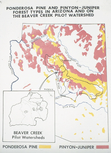
 The Beaver Creek Experimental Watershed - May 24, 2006 Jeff Schalau, County Director, Associate Agent, Agriculture & Natural Resources Arizona Cooperative Extension, Yavapai County The Beaver Creek Experimental Watershed should be of interest to Verde Valley residents because it is a major research area in our backyard. A watershed (also called a drainage basin or catchment basin) is a geographic area of land that drains water to a shared destination. The Beaver Creek Experimental Watershed in on the Coconino National Forest and includes Stoneman Lake, Rimrock, Lake Montezuma, and McGuireville. Below is a brief history and some of the research results. In 1955, ranchers, scientists from the USFS Rocky Mountain Research Station, and representatives from the Salt River Project were concerned that woody vegetation was reducing the flow of water and available forage for livestock across the state. As a result, the University of Arizona was commissioned to investigate the potential for improving water yield from the Arizona’s forests and rangelands. Initial investigations suggested that surface water runoff could be increased if high water using plants such as trees and shrubs were replaced with low water using plants such as grasses and forbs. The Beaver Creek Experimental Watershed was established by the US Forest Service to evaluate water runoff changes after altering vegetation using various timber harvest strategies, herbicides, and burning. Changes in livestock forage, timber production, wildlife habitat, recreation, and soil movement were monitored in addition to surface runoff. Between 1957 and 1962, 20 specific sub-watershed study units within the Beaver Creek Experimental Watershed were designated to test the effects of several vegetation management practices on water yield and other resources. Of the 20 sub-watersheds, 18 were watersheds from 66 to 2,036 acres where specific vegetation modifications could be tested on a pilot basis. The other two, encompassing 12,100 and 16,500 acres, were watersheds set aside to demonstrate the effects of management practices on areas of the size land managers work with daily. Before any vegetation was changed, runoff from each sub-watershed was measured using gauging stations and sediment traps for several years to determine streamflow variations under pretreatment conditions. During this time, the quantity and quality of other natural resources also were inventoried. After pretreatment measurements completed, six watersheds were designated as untreated "controls" that would provide comparisons with treated areas. Pinyon/juniper areas were of particular interest to researchers. Three techniques were used to remove pinyon and juniper trees. These were uprooting, herbicide spraying, and cutting, respectively. Herbicide spraying was the only treatment to yield a significant streamflow increase. However, the government carefully controls the use of herbicides on public lands, limiting the general use of this technique. Mechanical removal, such as uprooting or cutting, is the primary means for converting pinyon-juniper woodlands to other types of vegetation. Increased grass was the most noticeable change triggered by pinyon-juniper removal. However, the cost of removal usually is more than the value of the livestock forage gained unless the trees can be sold for fence posts or firewood. In addition, if the grasslands are not maintained by periodic burning and/or mechanical tree removal, trees return to these sites over time. Pinyon-juniper removal also caused wildlife changes, particularly among small mammals and birds. For example, birds that feed in trees are replaced by ground feeders. The predominant game animal during the studies was mule deer. They were affected little by tree removal when woodland cover was left not far from the openings. However, more forage was made available in early spring when deer often need additional nourishment. Today, elk would likely be considered a major game species in the area. Records from the pinyon-juniper sub-watersheds showed that erosion rates and sediment loads (amount of soil suspended in the runoff) in the streams varied sharply with the intensity of storms. A heavy storm soon after the trees were removed from one watershed washed away much soil. By and large, average sediment loads from the treated watersheds did not exceed those from the control watersheds significantly. The Beaver Creek Experimental Watershed and the researchers that worked there generated lots of excellent scientific data. Today, hydrologists and water managers are still interested in vegetation manipulation to increase water yield. Research in this field continues as we place increasing demands on our water resources in the arid southwest. More information about the Beaver Creek Experimental Watershed is available on the Internet at http://cals.arizona.edu/OALS/watershed/beaver/ and http://www.mpcer.nau.edu/beavercreek/. The University of Arizona Cooperative Extension has publications and information on gardening and pest control. If you have other gardening questions, call the Master Gardener line in the Cottonwood office at 646-9113 ext. 14 or E-mail us at mgardener@verdeonline.com and be sure to include your address and phone number. Find past Backyard Gardener columns or submit column ideas at the Backyard Gardener web site: http://cals.arizona.edu/yavapai/anr/hort/byg/. |