Special issue: Selected papers from the IALC Conference:
Assessing Capabilities of Soil and Water Resources in Drylands:
The Role of Information Retrieval and Dissemination Technologies
Special issue: Selected papers from the IALC Conference: Assessing Capabilities of Soil and Water Resources in Drylands: The Role of Information Retrieval and Dissemination Technologies |
|
by Otto Spaargaren, Jan Erik Wien, Onno Roosenschoon, and Willem-Jan Jansen
| "The pilot phase of the Virtual Soil Museum focused mainly on (a) exploring the technical possibilities of combining 3D Virtual Reality with 2D soil information generated from available data sets, and (b) the opportunities of such a combination in relation to the objectives of the Virtual Soil Museum... ." |
Introduction(Back to top)The International Soil Reference and Information Centre (ISRIC) in Wageningen, the Netherlands, has collected some 970 undisturbed soil profiles from 75 countries during the past 35 years. All these soils are accompanied by a description of the environmental setting and a profile description using FAO standards (FAO-ISRIC 1990); sample material for physical and chemical analyses; samples for microscopic studies; photographs and slides of their field setting; vegetation, land use, crops and profile details; and documentation in the form of soil reports and maps. Soil analyses have been carried out in ISRIC's laboratory following internationally accepted methods (Van Reeuwijk 2002). The purpose of bringing together this collection of soils lies back in the '60s when the United Nations Food and Agricultural Organization (FAO) and the United Nations Educational, Scientific and Cultural Organization (UNESCO) started the project "Soil Map of the World". This project aimed at preparing a soil map of the world at a scale of 1 : 5 000 000, using existing information. It took some 25 years to complete this map, which is still the most comprehensive and detailed overview of soil in the world (other world maps are the Russian Soil Map of the World at a scale of 1 : 10 000 000, and the USDA Soil Map of the World, which is largely derived from the FAO-UNESCO map). During the early years of the project it was felt necessary to create a center where materials documenting the soils of the world were collected. In 1964, the General Assembly of UNESCO adopted a resolution to this extent, and the Dutch Government agreed to fund such a center. In 1966 it was established, first as the International Soil Museum (ISM); from 1984 onwards it has been known as the International Soil Reference and Information Centre (ISRIC). ISRIC is the World Data Centre for Soils of the International Council for Sciences (ICSU). The soil reference collection and accompanying documentation, especially the "World Soil Museum," is mainly used by university and high school groups, researchers and persons preparing for a mission abroad. It has the disadvantage that it can only be consulted by visiting ISRIC. None of the data, photos or documents is yet online. During an email survey conducted in 1999, some 70% of the respondents indicated their interest in viewing and consulting the collection online, together with other datasets and services ISRIC can provide. The results of this survey have subsequently been used to formulate an Internet Policy Plan (IPP) (Engelhard 1999) for ISRIC. One of the components of the IPP is the construction of a "Virtual Soil Museum," where visitors can view the collection and the accompanying data online. The Virtual Soil Museum(Back to top) The objective of the Virtual Soil Museum is (a) to enhance access to the ISRIC soil reference collection by a broad public, thus increasing its scientific, educational and cultural-historical value; (b) to become a meeting place for those interested in soils of the world, with particular focus on sustainable use of soil to obtain food security; (c) to promote ISRIC activities; and (d) to serve as digital signboard to attract visitors to Wageningen. To meet these objectives the virtual soil museum must fulfill requirements to suit various user groups. Presently, the main user groups of the real "World Soil Museum" are academic (students, lecturers, researchers); only about 20% of the visitors are non-academic. Therefore, the design of the Virtual Soil Museum must be attractive to all potential visitors. |
|
|
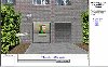
The pilot project of the Virtual Soil Museum focuses mainly on the design and development of the technical infrastructure and information generation. Visitors enter the Virtual Museum through a web browser. Before entering the Multi User world, users need to install the ActiveX plug-in component to display the 3D worlds. The plug-in can be installed automatically or manually using the Installation option in the opening screen (Figure 1). |
|
|
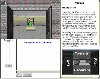
The opening HTML page of the Virtual Museum is divided into three sections. The size of the sections can be changed on-screen by moving the borders. The first section is the three-dimensional Museum section, through which the user can navigate using the mouse or the keyboard's up, down, right and left arrows. Details on the use of the controls in the 3D environment are given in a second section of the opening screen with information about the ISRIC Multi User Server (Figure 2). |
|
|
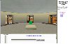
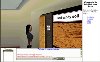
The 3D section of the Museum gives pictures of ISRIC's soil monoliths (hardened soil profiles) and some additional images, which form the gateway to the underlying information. In this prototype soils from arid regions have been chosen to serve as an example of how other compartments of the museum with different topics may look (Figure 3). In the future the main entrance hall will be used to provide general information about the Virtual Soil Museum, information about soil distributions in the world and a help desk to guide visitors through ISRIC's virtual world of soils. |
| Thumbnail links to Figs. 4 (~23K), 5 (~22K), and 6 ~22K) |
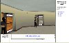
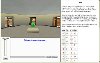
The multi-user function of the Virtual Soil Museum enables more than one person to visit the Museum at the same time. Each visitor has an avatar (that is, a digital representation of the visitor in the digital world), which makes it possible for online visitors to "see" each other (Figure 4). In this way, the Museum can be a meeting place and a discussion platform for soil matters (Figure 5). The third section of the site displays the multi-user functionality such as the "chat" window. Details on the chat function, how to "warp" (to go quickly to a person in the Museum) and how to "whisper" (to talk to one person in the Museum only) are explained under Chat in the ISRIC Multi User Server section (Figure 6). Other functionalities, such as a "message board," may be added in the future. By clicking on items in the museum, for example on the information sign with the soils, the visitor gets information about the soil and its environment in the 2D section of the site. Presently, the information is dynamically generated from a MS-Access database called the ISRIC Soil Information System (ISIS). |
|
|
The ISIS database is relational, consisting of numerous logically linked tables (Figure 7). These include data about the site of the soil; its classification; its morphological, physical and chemical properties, including data on soluble salt content and elemental composition of the fine earth and clay fractions; the mineralogy of clay and sand fractions; trace elements; extensive data from the nearest climate station in FAO's climatic database; and images related to the soil in question. |
|
|
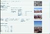
Links are provided to pictures of the soil, landscape, land use and vegetation. The output is in the form of a HTML page providing information from the various tables (Figure 8). For the prototype only a few columns of selected tables have been linked. By clicking on the photos, a larger image is obtained that can be downloaded. Discussion(Back to top) One of the setbacks during the development of the pilot Virtual Museum appeared to be the data format. The present MS-Access data structure is not suitable for a large number of concurrent users as envisaged in the Virtual Soil Museum. Moreover, authorization of the data is not easily implemented using the MS-Access data structure. Therefore it has been decided to focus for the present on restructuring the data format to meet the requirements for optimal use over the Internet. In the near future the information will be generated from an Oracle Portal database, which is also the platform used for many other data sets in use by the Wageningen UR. It is envisaged to add literature and maps to the database once the Oracle environment is realized. The pilot phase of the Virtual Soil Museum focused mainly on (a) exploring the technical possibilities of combining 3D Virtual Reality with 2D soil information generated from available data sets, and (b) the opportunities of such a combination in relation to the objectives of the Virtual Soil Museum, being a meeting place for people interested in soil, an attractive outlet for soil information, a tool for education and creation of soil awareness, and a digital signpost for ISRIC. It permits the highlighting of environmental issues such as land degradation and conservation using multi-media technology, and enables linking with programs such as "World Overview of Conservation Approaches and Technologies (WOCAT)" with their underlying databases. It thus can contribute to creating awareness among a wider public about the preciousness of soils as one of the most important resources for world food and fiber production and sanitation. As such, the present set-up, with all its shortcomings, seems to be a suitable vehicle to achieve these objectives. Almost endless possibilities to meet user requirements (chat room, bulletin board, discussion groups, mailing list functions, privatized museum room) can easily be combined with an attractive visualization of soils and their surroundings, their functions and use, and their role in sustainable development. The attractive visualization can be further enhanced by multimedia applications such as sound (possibility for guided tours) and video (for example about soil life or soil management practices). Next steps in the development of the Virtual Soil Museum will be adaptation of the prototype according to the suggestions and criticism, the outcome of an internal discussion within ISRIC on the role of the Virtual Soil Museum as outlet of ISRIC information, and consultation with multiple user groups to identify their wishes and requirements. Acknowledgments(Back to top) References(Back to top) FAO-ISRIC. 1990. Guidelines for soil description. 3rd ed. (Revised). Rome: Food and Agricultural Organization of the United Nations. Van Reeuwijk L.P., ed. 2002. Procedures for soil analysis. 6th ed. Wageningen, the Netherlands: International Soil Reference and Information Centre; Rome: FAO. |
![]()
(Back to top)
Otto Spaargaren, International Soil Reference and Information Centre - ISRIC,
PO Box 353, 6700 AJ Wageningen, The Netherlands, email: spaargaren@isric.nl,
website: http://www.isric.org.
Jan Erik Wien, Wageningen Software Labs - W!SL, PO Box 47, 6700 AA Wageningen, The Netherlands, email: j.j.f.wien@wisl.nl, website: http://www.wisl.nl.
Onno Roosenschoon, Wageningen Software Labs - W!SL, PO Box 47, 6700 AA Wageningen, The Netherlands, email: o.r.roosenschoon@wisl.nl, website: http://www.wisl.nl.
Willem-Jan Jansen, Green Dino Virtual Realities, Generaal Foulkesweg 5, 6703 BH Wageningen, The Netherlands, email, willem-jan@virtual-reality.nl, website: http://www.virtual-reality.nl
About the Arid Lands Newsletter