community | data | history | publication list | partners
Aerial Photos
The Basemap
Developing a GIS
IBWC Graphs
Ground Photos
Imaging Requirements
Developing a Basemap
Remote Sensing
Satellite Images
Techniques for Mapping
Vegetation Mapping
|
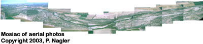
Aerial-level Data
Aerial surveys of the delta may be flown in transects around the core study areas with a MODIS Quick Airborne Looks (MQUALS) package consisting of Exotech radiometers with TM and MODIS filters, an infrared thermometer, and a multispectral (blue, red, NIR) camera, mounted on a small aircraft (Huete et al., 1999). "The MQUALS sensor package may be used to acquire overlapping, 1,000 m, aerial imagery and "calibrated" top of the canopy reflectance measurements of the Colorado River floodplain. Moran et al. (1997c) review techniques for converting airborne imagery to reflectances. To the extent possible, these airborne data may be collected concurrently with ETM+/ MODIS overpasses and ground data collection. "Processing of the radiometric data may rely on ground measurements made over a calibrated "spectralon" reference panel and cross calibration of the sensors to a standard reference panel housed in the Optical Sciences Center at the University of Arizona.  The
MQUALS package, not only documents surface conditions at fine spatial
resolution (< 0.5 m), but also enables the determination of percent
vegetation cover, soil type, soil salinity, and species composition.
MQUALS also provides a mechanism for up scaling ground measurements
and aircraft based 'reflectance' and 'emittance' measurements to image
based resolutions (e.g. ETM+, MODIS) for region wide monitoring purposes
(Glenn et al., 2001c)." The
MQUALS package, not only documents surface conditions at fine spatial
resolution (< 0.5 m), but also enables the determination of percent
vegetation cover, soil type, soil salinity, and species composition.
MQUALS also provides a mechanism for up scaling ground measurements
and aircraft based 'reflectance' and 'emittance' measurements to image
based resolutions (e.g. ETM+, MODIS) for region wide monitoring purposes
(Glenn et al., 2001c)." |